Papakura
It is located on the shores of the Pahurehure Inlet, approximately 32 kilometres (20 mi) south of the Auckland City Centre.
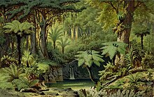
The area was settled by Tāmaki Māori in the 13th or 14th centuries, who utilised the resources of the Hunua Ranges and Manukau Harbour.
The town developed significantly during the construction of the Great South Road, and was a military outpost during the Invasion of the Waikato.
From the 1950s, Papakura and the surrounding areas urbanised, in part due to the construction of the Auckland Southern Motorway.
[3][4] While kura is usually interpreted to be a reference to the red soil of the area,[5][3][6][7] ethnographer George Graham offers an alternative translation of Papakura, "Flat of the Moa".
[8][6] A name associated with the location of the modern township of Papakura is Wharekawa,[8][7] while the Coles Crescent area adjacent to the Pahurehure Inlet was known as Waipapa.
[3] It is located between the suburb of Takanini to the north, and the rural settlements of Drury to the south and Karaka to the west.
To the east of Papakura is Pukekiwiriki, a basalt volcano within the South Auckland volcanic field that erupted an estimated 1,000,000 years ago.
[10][11][12][13] Many Māori migration canoes visited the wider area, including the Matahourua, Aotea, Mātaatua, Tainui, Tākitimu, Tokomaru, Te Wakatūwhenua and Moekākara.
[17] The site became a home for the Tāmaki Māori people who descended from her, known as Ngā Mārama, who later became a part of the Waiohua confederation.
[3][8] Tāmaki Māori of the Papakura area thrived by utilising the resources of the Manukau Harbour, forests of the Hunua Ranges and by creating large-scale gardens, primarily on the slopes of Pukekiwiriki.
[15][20] Around the year 1740, a conflict between Ngāti Whātua and Waiohua led to the death of paramount chief Kiwi Tāmaki.
Waiohua gradually returned to the southern Manukau Harbour, including Papakura, living in disbursed villages based on seasonally available resources.
[21] Waiohua descendant tribes relocated to the Waikato under the protection of Pōtatau Te Wherowhero, returning gradually during the early 1830s.
[8] In January 1842, the Crown purchased the Papakura block from Ngāti Taihaua, a hapū with ties to Ngāi Tai and Te Ākitai Waiohua, that included rangatira Īhaka Takaanini.
[25] The first European settler mentioned in newspapers is George Rich, who is described as farming and hunting wild boars at Papakura in 1844.
[25] The construction of Great South Road led to a population boom in Papakura, which became a military outpost staging point for the war.
Most people refused due to strong links to Tainui, leaving for the south before the Government's Invasion of the Waikato.
Small numbers of people remained, in order to tend to their farms and for ahi kā (land rights through continued occupation).
[35][36] Most Māori occupants of the Papakura area felt they had no choice due to their strong ties to Tainui and Pōtatau Te Wherowhero, and were forced to flee to the Waikato in the south.
The military barracks and stables in the town were disbanded, and local residents struggled, no longer able to supply the soldiers.
[41] In 1875, Papakura railway station opened, linking the town to Auckland to the north and Hamilton to the south.
[29] The opening of the railway station helped grow the profitability of dairy farming, which became a major industry in Papakura in the 1880s.
[43] The 1890s saw a major increase in kauri gum diggers visiting Papakura and Takanini, many of whom were Māori and Dalmatian immigrants.
The flight was piloted by Vivian Walsh and was carried out in a Howard Wright 1910 Biplane, the parts for which were imported from England in 1910 and assembled by members of the Auckland Aeroplane Syndicate.
[54] By the mid-20th century horse breeding became common,[3] and as the motorway was being constructed, industrial businesses were established in the Takanini and Papakura areas.
[101] In addition to the Local Council Chambers, Papakura is served by a large police station (one of Auckland's busiest), a District Court, and a WINZ office.
The army base was made much smaller in the 2010s and become a residential area for a large number of modern houses, both detached and terraced.
[103] State Highway 1 and the North Island Main Trunk railway run through the Papakura District.
State Highway 1 ran down Great South Road through central Papakura until 1965, when it was bypassed by the Auckland Southern Motorway.