Paria River
It is formed in southern Utah, in southwestern Garfield County from several creeks that descend from the edge of the Paunsaugunt Plateau, meeting just north of Tropic.
It joins the Colorado from the northwest approximately 5 mi (8 km) southwest of Page, Arizona and the Glen Canyon Dam.
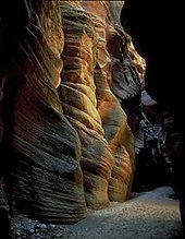
The lower 20 mi (32 km) of the river are within the Paria Canyon-Vermilion Cliffs Wilderness, which is administered by the Bureau of Land Management; a permit is required for any overnight visit.
To help restore the salinity of the Paria and Colorado Rivers to more natural levels, the Tropic and East Fork Irrigation Company have proposed replacing the last 5.5 miles of the ditch with a pipeline.
The Paria and several nearby rivers and canyons also are the site of several well-preserved specimens of Native American petroglyphs, prehistoric drawings, and symbols carved into stone.