Adelaide Park Lands
[11][3] Light chose a site spanning the River Torrens (known as Yatala by the Kaurna people[12]), and planned the city to fit the topography of the landscape, "on rising ground".
The Emigration Regulations appearing in the South Australian Gazette and Colonial Register published in London on 18 June 1836 instructed that the site of the first town be divided into 1,000 sections of an acre each.
[3][14][12] Adelaide's characteristic geometrical grid pattern is not unique: apart from earlier precedents going back to ancient Greece,[15][16] it follows part of a series of rules created by Spanish planners for their colonial cities, known as the "Law of the Indies".
[citation needed] Extensive felling of trees, quarrying and dumping of rubbish continued, which combined to give the Park Lands an unsightly appearance.
In the late 19th century John Ednie Brown, the government's Conservator of Forests, was commissioned by the City Council to prepare a blueprint for the beautification of the Park Lands.
Major progress was made in planting and landscaping the Park Lands during his tenure (1899–1932) and further improvements such as creation of new gardens and boating lakes were carried under the authority of William Veale, the Town Clerk (1947–1965).
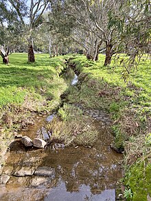
Some of the remainder is remnant or regenerated Adelaide Plains grasslands or grassy woodlands,[28] of which 230 hectares (570 acres) have been designated and developed by the city council as areas for native fauna and flora.
Developments in the early 2000s focused on maintenance and upgrading of recreational facilities, and removal of remnant grasslands and open grassy woodlands, particularly through urbanisation and the Greening of Adelaide tree planting and replacement programs.
At the time the Act was proclaimed, Premier Mike Rann announced[29] that a major return of alienated Park Lands would be made at the western edge of the city.
The area to be returned, 5.5 hectares of land at the west end of Park 25, occupied since 1879 by the Thebarton Water Depot, lies between East Terrace (now James Congdon Drive), Port Road and the railway lines.
The plans were unveiled in 2011[30] and the land, which was mallee box woodland[31] prior to European settlement, was developed and landscaped with more than 23,000 trees and shrubs as an urban forest.
The numbering, which starts in the North Park Lands (at the Adelaide Golf Links), and increases clockwise around the perimeter, was applied in September 1882.
After a few weeks, Bromley moved camp to the north side of the river at the request of the Kaurna people, to the site known as Piltawodli (later revised to Pirltawardli[44]), meaning "possum place"[46] and also known as the "Aboriginal Location".
[46] Pirltawodli was designed by the colonial government to keep Aboriginal people confined and settled in a type of reserve, so that the rest of the land could be systematically colonised.
[47] William Cawthorne, a frequent visitor and close friend of Kadlitpina ("Captain Jack"), loved the Kaurna Palti "corroboree" and their material culture, and was responsible for recording many names of artefacts.
[47] His Rough Notes on the Manners and Customs of the Natives, written in 1844, was published in the 1925-26 Proceedings of the Royal Geographical Society of Australasia (SA Branch).
[47] Pardipardinyilla[52] 'swimming place'[53][34][33] 17 hectares[54] Denise Norton was the first South Australian to represent Australia at the Olympic or Commonwealth Games – in the sport of swimming.
The Park is dominated by a number of sporting ovals and associated facilities licensed to the University of Adelaide, including a tennis pavilion, a grandstand, and changing rooms.
There are sports fields in the centre, and the South Park Lands creek runs through the southern part, which has been revegetated with open woodland.
[106] On 14 May 2021, a scheduled cultural burn took place Tuthangga by representatives of the Kaurna people, in a highly symbolic moment after years of preparation to restore the ancient practice.
The project, called Kaurna Kardla Parranthi, was undertaken with the support of the City of Adelaide,[107] and was part of the ecological management plan for a key area of biodiversity in the park.
[117] Kurrangga[118] 'blue gum place'[33][119][34] 30.1ha[120] Contains a boule/petanque area, assorted playing fields, a mountain-bike / BMX-bike track, one of the three Glover Playgrounds, et al. Licences and leases include Pulteney Grammar School (6 ovals, cricket nets, 3 lawn tennis courts, 2 grass volleyball courts, and facilities), Adelaide Harriers Athletics Club (athletics oval / running track), Club d'Petanque d'Adelaide, TreeClimb (High Ropes Adventure Course) and others.
[33][136][34] 57.43 ha[137] Sir George Strickland Kingston was Deputy Surveyor-General under Colonel Light, one of the party that found the River Torrens, and first Speaker of the South Australian House of Assembly.
It was the site of the former, now demolished, Emigration Square 1837-1849, the former Observatory, and the Post and Telegraph Store (off West Terrace) depicted in Colonel Light's 1837 Plan for Adelaide.
[3][138][140] Narnungga[141] "native pine place"[33][142][34] 24ha[143] Gladys Elphick MBE was a Kaurna elder who, among other things, was founding president of the Council of Aboriginal Women of South Australia (1964–73).
The eastern part contains assorted sports grounds, including the Karen Rolton Oval at the east end of the park.
It is dissected by railway lines and the River Torrens, and much of the south-eastern part of the park is occupied by the new Royal Adelaide Hospital and Medical Research and Teaching precincts, and is not accessible to the public.
[153][154] As of 2006, buildings and other structures included the Thebarton Police Barracks (which includes the Road Safety Centre[155]); the new Royal Adelaide Hospital; SAHMRI (South Australian Health and Medical Research Institute); various hospital and University of Adelaide buildings on the former site of the City Sk8 Park; the remainder of the railway yard (the bulk of which was relocated to Dry Creek); assorted broad gauge and standard gauge railway lines and bridges, six tennis courts, some boat houses and rowing clubs' clubhouses.
[167] An example of one such source of controversy is the Victoria Park racecourse and associated areas south-east of the city centre which have been used for motor racing events for short periods of each year.
"Under Light's direction, the intention to locate public facilities outside of the main street grid is beyond question", he said in a report commissioned by developers KBR.