Paroo-Darling National Park
This region covers the arid catchments of the Paroo River (Peery and Poloko Lakes) and the Paroo-Darling confluence to the south.
Aboriginal heritage has been protected here and evidence of a lifestyle spanning back many thousands of years in the hearth sites, stone tool scatters and scarred trees that had supplied bark.
They were followed soon after by others in search of pastures for sheep and cattle in the 1860s and the area became part of the 8,480 square kilometres (3,274 sq mi) Momba Station.
[5] From 1902 Momba was successively subdivided until 1950 when the remainder was divided into ten leases including Peery, Mandalay and Arrowbar.
[4] The park comprises the former pastoral properties of Peery, Mandalay and Arrowbar and covers an area of approximately 96000 hectares (237000 acres).
[4][8] The park is set in a landscape of grey cracking clays and red sand hills along the Darling River floodplains.
When dry, Peery Lake is the only location in New South Wales where the Great Artesian Basin mound springs are visible in a lakebed.
[4] The predominant vegetation type of this bioregion is dominated by mulga (Acacia aneura) and other woody shrub species.
[6] The climate of the region is described as arid with low average rainfall which is highly variabile leading to extended droughts and occasional flooding rains.
[12] The landforms protected in the park include the Peery Hills with rugged gorges and low escarpments, ephemeral lake basins, sand plains and dune fields.
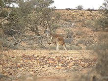
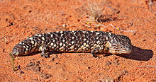
[4] Other species recorded included the lace monitor (Varanus varius), shingleback (Tiliqua rugosa), carpet python (Morelia spilota metcalfei) and mulga snake (Pseudechis australis).
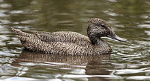
[17] Peery and Poloko Lake also provide important habitat for migratory shorebirds that are covered by international bird agreements JAMBA, CAMBA and ROKAMBA.
[4][5] The park supports two threatened ecological communities listed as endangered under the NSW TSC Act.
The park supports one nationally threatened plant species salt pipewort (Eriocaulun carsonii), which is listed as endangered under the EPBC Act, and four plant species (Nitella partita, Dysphania platycarpa, Eriocaulon carsonii, Dentella minutissima) that are listed as endangered under the NSW TSC Act.
[19] Mound springs are a threatened community because they occupy a specialised habitat being restricted to locations where artesian water comes to the surface.
[27] Over much of the arid zone in Australia grazing by domestic stock and feral species such as rabbits and goats has resulted in modification in the structure and composition of plant communities.
[28] The park was previously used for grazing which effected the plant communities through increased erosion and reduced recruitment and establishment of species such as lignum (Muehlenbeckia florulenta).
[7] Rabbits, feral goats and domestic stock from neighbouring pastoral properties continue to pose a threat to the ecosystems in the park.
[4][7] Introduced fish such as European carp (Cyprinus carpio) threaten the aquatic ecosystems in the park as they compete with and prey on native species.
[15][16] Changes to this naturally variable flow regime will impact on the ecological characteristics and the extent of these wetland ecosystems.
[4] The national park can be accessed via dry weather roads, from the villages of either White Cliffs, located, some 20 kilometres (12 mi) away, or Wilcannia.
The visitor centre at White Cliffs is able to provide further up-to-date information on the Paroo-Darling National Park.
Camping is permitted at the Coach and Horses campground at the old Wilga Station which is approximately 50 kilometres (31 mi) east of Wilcannia.