Pavonia, New Netherland
[1] The first European to record exploration of the area was Robert Juet, first mate of Henry Hudson, an English sea captain commissioned by the Dutch East India Company.
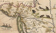
At that time the area was inhabited by bands of Algonquian language speaking peoples, known collectively as Lenni Lenape and later called the Delawares.
In 1629, with the Charter of Freedoms and Exemptions, the Dutch West India Company started to grant the title of patroon and land patents to some of its invested members.
The title came with powerful rights and privileges, including creating civil and criminal courts, appointing local officials, and holding land in perpetuity.
These first settlers were relieved of the duty of public taxes for ten years, but were required to pay the patroon in money, goods, or services in kind.
[7] As was required, Pauw purchased the land from the indigenous population, although the concept of ownership differed significantly for the parties involved.
[10] His agent set up a small factorij and ferry slip at Arresick on the tidal island that stills bears his anglicized name, Paulus Hook.
[11] Pauw, however, failed to fulfill the condition of establishing a community of at least 50 permanent settlers and was required to re-sell his speculative acquisition back to the company.
During 1634 a homestead was built at Ahasimus for Cornelis Hendriksen Van Vorst (Voorst), whose later descendants would play a prominent role in the development of Jersey City.
Although the settlements were small, they were strategic in that they were a foothold on the west bank of what had been named the North River across from New Amsterdam and were important trading-posts for the settlers and indigenous people, who dealt in valuable beaver pelts, and they were early attempts at populating the newly claimed territory.
His solution was to attempt to exact tribute from the native peoples with claims that the money would buy them protection from rival groups.
[14] Kieft decided, against the advice of the council of Twelve Men, to punish the native population who had taken refuge among the Netherlanders (their presumed allies), when fleeing raiding Mahican from the north, by attacking Pavonia and Corlear's Hook.
[6] The initial strike which he ordered on February 25, 1643, and took place at Communipaw, was a massacre: 129 Dutch soldiers killed 120 Native Americans, including women and children.
The colony grew and the situation remained relatively peaceful until 1655, when Pavonia and Staten Island were attacked by a united band of approximately five hundred Lenape.
[6][21] During 1658, wishing to further formalize agreements with the Lenape, Stuyvesant agreed to "re-purchase" the area "by the great rock above Wiehacken," then taking in the sweep of land on the peninsula west of the Hudson and east of the Hackensack River extending down to the Kill Van Kull in Bayonne.
[24] Its semi-independent government was granted on September 5, 1661, by Stuyvesant, as part of his efforts re-gain a foothold on the North River's western shore and expand beyond New Amsterdam on the southern tip of Manhattan, under the condition that a garrison be built.
Located atop Bergen Hill, it was part of the original patroonship, close to the southern end of the Hudson Palisades.
Although the entire region was originally Pavonia, the name now tends to be associated with the former Jersey City area of the Horseshoe encompassing Harsimus Cove, Hamilton Park, and WALDO-Powerhouse.