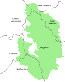
Peak District Boundary Walk
The route was developed by the Friends of the Peak District (a branch of the Campaign to Protect Rural England) and was launched on 17 June 2017.
The route is waymarked with green markers and uses existing footpaths, tracks, quiet lanes, disused railway lines and a canal towpath.
The start and finish is at the King's Head pub on Buxton Market Place, where a plaque has been installed by the Peak & Northern Footpaths Society (PNFS).
The terrain covers open moorlands of the South Pennines, the limestone scenery of the Derbyshire Dales, woodlands, reservoirs and rural farming countryside.
[4] The trail is divided into twenty stages of about 10 miles (16 km) long, in a clockwise direction around the Peak District.
Marsden to Holme Heading east from Marsden over Deer Hill Moss, past Deer Hill Reservoir, across fields and along lanes past Meltham, up Royd Edge and Harden Moss Road track, down to Digley Reservoir, across the dam, following the Kirklees Way into Holme (8.5 miles/13.7 km).
Beeley to Winster Up the hillside to woods overlooking Chatsworth Park, back down to cross the River Derwent and the River Wye at Rowsley, down the lane past Stanton Woodhouse and up to Nine Ladies stone circle, continuing across Stanton Moor, down a footpath into Winster (6 miles/9.7 km).
Waterfall to Tittesworth Reservoir Across fields to join the Hamps Way along the River Hamps, along a track over fields to Onecote village, heading north along a farm track over the hill beyond Mixon, along a minor road to the former Mermaid Inn on the Morridge, taking a footpath west down to Upper Hulme below The Roaches escarpment, along the Staffordshire Moors Walks to Tittesworth Reservoir (11.4 miles/18.3 km).
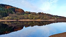
Tittesworth Reservoir to Wildboarclough Along a lane to Meerbrook across the reservoir, heading north up a footpath around the end of a ridge, across farmland to the River Dane, crossing a footbridge, following footpaths across hilly farmland, up the lane beside Clough Brook to Wildboarclough (10.1 miles/16.3 km).
Wildboarclough to Bollington Up and over Shuttlingsloe hill summit (the highest point on the Boundary Walk), down the footpath into Macclesfield Forest, past Trentabank, Ridgegate, Bottoms and Teggs Nose reservoirs, along the Gritstone Trail up through Tegg's Nose country park onward to Rainow village and along Kerridge Ridge past White Nancy monument to Bollington (8.5 miles/13.7 km).