Pemigewasset River
[1] The name "Pemigewasset" comes from the Abenaki word bemijijoasek [bəmidzidzoasək], meaning "where side (entering) current is".
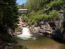
The remainder of the northern Pemi, from Lincoln to Ashland, passes over copious gravel bars and attracts numerous boaters and fishermen.
Below Ashland, the river is impounded by the Ayers Island Dam, a hydroelectric facility, for over five miles.
A short stretch of heavy whitewater is found below the dam, before the river reaches the impoundment zone for the Franklin Falls flood control reservoir.
The Pemigewasset watershed consists of over 1,100 miles (1,800 km) of rivers and 17,000 acres (69 km2) of lake, pond, and reservoir area.