Pennines
[12] It did not become a common name until the 18th century and almost certainly derives from modern comparisons with the Apennine Mountains, which run down the middle of Italy in a similar fashion.
[11][dubious – discuss] Following an 1853 article by Arthur Hussey,[13] it has become a common belief that the name derives from a passage in The Description of Britain (Latin: De Situ Britanniæ),[15] an infamous historical forgery concocted by Charles Bertram in the 1740s and accepted as genuine until the 1840s.
In 2004, George Redmonds reassessed this, finding that numerous respected writers passed over the origin of the mountains' name in silence even in works dedicated to the topological etymology of Derbyshire and Lancashire.
[11] In fact, Redmonds found repeated comparisons with the Italian Apennines going back at least as early as William Camden (1551–1623),[16] many of whose placenames and ideas Bertram incorporated into his work.
The etymology of the Apennines themselves—whose name first referred to their northern extremity and then later spread southward—is also disputed but is usually taken to derive from some form of Celtic pen or ben ("mountain, head").
[20][21][22] Various towns and geographical features within the Pennines have names of Celtic origin, including Pennington, Penrith, Pen-y-ghent, Pendle Hill, the River Eden, and Cumbria.
[23] Northumbrian/borders terms are used in South Tynedale, Weardale, and Allendale, such as burn (stream), cleugh (ravine), hope (valley), law (hill) and linn (waterfall).
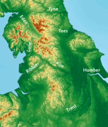
The rivers Eden, Ribble, Dane and tributaries of the Mersey (including the Irwell, Tame and Goyt) flow westwards towards the Irish Sea.
On the eastern side of the Pennines, the rivers Tyne, Wear, and Tees all drain directly to the North Sea.
The Swale, Ure, Nidd, Wharfe, Aire, Calder and Don all flow into the Yorkshire Ouse, and reach the sea through the Humber Estuary.
The River Trent flows around the southern end of the Pennines and northwards on the eastern side taking water from tributaries, principally the Dove and Derwent.
The Trent drains the east and west sides of the southern Pennines, also reaching the North Sea through the Humber Estuary.
[37] According to the Köppen classification, the Pennines generally have a temperate oceanic climate (Cfb) like the rest of England, but the uplands have more precipitation, stronger winds and colder weather than the surrounding areas.
Many towns and cities are located along rivers flowing from the range and in northwest England the lack of natural aquifers is compensated for by reservoirs.
In some areas, precipitation has contributed to poor soils, resulting in part in moorland landscapes that characterize much of the range.
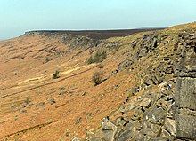
Here the shales and sandstones of the Millstone Grit form high hills occupied by moorland covered with bracken, peat, heather and coarse grasses;[40] the higher ground is uncultivable and barely fit for pasture.
[41] The uplands were controlled by the tribal federation of the Brigantes, made up of small tribes who inhabited the area and cooperated on defence and external affairs.
The Pennines were not a distinct political polity, but were divided between neighbouring counties in northeast and northwest England; a major part was in the West Riding of Yorkshire.
The Pennines contain the highest village in the United Kingdom, Flash, at 1,519 feet (463 m), near the southern end of the range in Staffordshire.
[45] The springs at Buxton and Ashbourne are exploited to produce bottled mineral water and there are approximately 2,700 farms in the National Park.
[50] In the Yorkshire Dales, tourism accounts for £350 million of expenditure every year while employment is mostly dominated by farming, accommodation and food sectors.
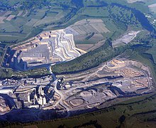
[51] The main economic activities in the North Pennines include tourism, farming, timber and small-scale quarrying, due to the rural landscape.
[53] Three trans-Pennine canals built during the Industrial Revolution cross the range: The first of three Woodhead Tunnels was completed by the Sheffield, Ashton-Under-Lyne and Manchester Railway in 1845, engineered by Charles Vignoles and Joseph Locke.
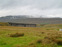
Between 1869 and 1876 the Midland Railway built the Settle-Carlisle Line through remote, scenic regions of the Pennines from near Settle to Carlisle passing Appleby-in-Westmorland and other settlements, some a distance from their stations.
[57] The Trans Pennine Trail, a long-distance route for cyclists, horse riders and walkers, runs west–east alongside rivers and canals, along disused railway tracks and through historic towns and cities from Southport to Hornsea (207 miles/333 km).
Eventually, the Celtic tongue of the Pennines was replaced by early English as Anglo-Saxons and Vikings settled the area and assimilated the Celts.
[61] As the Ice age glacial sheets retreated c. 11,500 BC trees returned and archaeological palynology can identify their species.
[62] On poorly drained impermeable areas of millstone grit, shale or clays the topsoil gets waterlogged in winter and spring.
[62] "In digging it away they frequently find vast fir trees, perfectly sound, and some oaks ..."Limestone areas of the Pennines in the White Peak,[64] Yorkshire Dales[65] and Upper Teesdale[66] have been designated as nature reserves or Important Plant Areas by the botanical conservation charity Plantlife,[67] and are nationally important for their wildflowers.
Other birds whose English breeding strongholds are in the Pennines include golden plover, snipe, curlew, dunlin, merlin, short-eared owl, ring ouzel and twite,[68] though many of these are at the southern limit of their distributions and are more common in Scotland.