Geology of Yorkshire
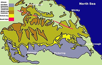
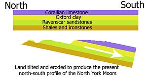
The North York Moors in the north-east of the county are Jurassic in age while the Yorkshire Wolds to the south east are Cretaceous chalk uplands.
The oldest rocks in Yorkshire are represented by a number of small inliers of Palaeozoic areas along the southern margin of the Askrigg Block to the north of the Craven faults.
The bordering seas began to be periodically invaded by deltas formed by rivers flowing from the adjacent higher ground.
The seas between the land masses were closed up and fold mountain ranges were formed along the closure line in many areas.
Later a marine transgression from the north established a shallow saline sea which produced a thickness of dolomitic limestone and significant evaporite deposits as it dried up.
[4] At the end of the Triassic the Rhaetic ocean spread its shallow waters over the deserts to start the Jurassic period.
Later in the Cretaceous seawater covered the whole of southern Britain and deposited a layer of chalk up to 550m thick forming a great swathe from Flamborough Head to the Channel coast.
It was also moved eastwards by the widening of the Atlantic Ocean and there was violent volcanic activity over north west Britain.
The highlands and lowlands of Britain assumed their present relative positions by the late Neogene, about 2 million years ago.
Seventeen cycles of cold and temperate climate are recognised in Britain with three positive episodes of actual glaciation being confirmed.
[1] There was scouring of material from the valley sides by the glaciers and this was deposited on lower ground as the ice retreated when the climate became warmer.
[2][4] The Pennines form an anticline which extends in a north–south direction, consisting of Millstone Grit and the underlying Carboniferous Limestone.
[3] In the Yorkshire Dales this limestone exposure has led to the formation of large cave systems and watercourses, known as "gills" and "pots".
Between the Northern and Southern areas of exposed limestone, between Skipton and the Peak, lies a narrow belt of gritstone country.
Here the shales and sandstones of the Millstone Grit form high hills occupied by moors and peat-mosses with the higher ground being uncultivable and barely fit for pastures.
[1] The landscape of the Pennines is generally upland areas of high moorland indented by the more fertile valleys of the region's various rivers.
The sandstones resist erosion so they form a recurring pattern of escarpments that stand out from the shallow mudstone floors of the valleys.
The major rivers crossing the area have carved broad valleys which have been glaciated and are floored by fertile alluvial deposits.
[3] The Magnesian Limestone belt forms a narrow north–south oriented strip of undulating land on the eastern edge of the Pennines overlooking the Vale of York.
Fluctuations in sea level produced different rock types varying from shales to sandstones and limestones derived from coral.
The boulder clay blocked the eastern end of the Vale of Pickering causing a permanent deviation in the course of the River Derwent.
Alluvium from the glaciers covers many areas to the north of the moors and in the Esk valley[3] The site of the post glacial Lake Pickering, the vale has a predominantly level topography covered by glacial drift deposits, with some rolling low ground on boulder clay and moraines in the far east.
[2] The hills are formed from Cretaceous chalk, and make an arc from the Humber estuary west of Kingston upon Hull up to the North Sea coast between Bridlington and Scarborough.
[2] Most of the area takes the form of an elevated, gently rolling plateau, cut by numerous deep, steep-sided, flat-bottomed valleys of glacial origin.
The chalk formation of the hills provides exceptionally good drainage, with the result that most of these valleys are dry; indeed, surface water is quite scarce throughout the Wolds.
[3] Geologically, Holderness is underlain by Cretaceous Chalk but in most places it is so deeply buried beneath glacial deposits that it has no influence on the landscape.
The glacial deposits form a more or less continuous lowland plain which has some peat filled depressions (known locally as meres) which mark the presence of former lake beds.