Pennsylvania Route 29
The southern section of PA 29 begins at an intersection with US 30 (Lancaster Avenue) near Malvern in East Whiteland Township, Chester County, heading north on six-lane divided South Morehall Road.
The road passes businesses and office parks, curving northwest and crossing the Chester Valley Rail Trail before coming to an interchange with the US 202 freeway.
The road runs between a quarry to the west and a lake and residential development to the east before it comes to a ramp providing access to the Pennsylvania Turnpike (I-76).
[3][4] At this point, PA 29 turns north onto a two-lane undivided State Road and runs through wooded areas with the abandoned railroad parallel to the east.
PA 29 passes under the abandoned railroad line and enters Schuylkill Township, heading through a mix of woods and fields with some homes parallel to the creek.
The route curves east and crosses the Perkiomen Trail before heading past a shopping center to the north and homes to the south.
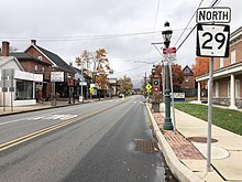
The road narrows to two lanes and turns north, heading past more businesses and widening to a four-lane divided highway as it comes to an intersection with East Main Street.
Here, PA 29 crosses East Main Street and curves northeast before it heads north along two-lane undivided 1st Avenue, running along the west bank of the Perkiomen Creek.
Past this junction, the road runs through more woodland with some residential and commercial development west of the creek, passing east of Perkiomen Valley High School and heading through Graterford.
The two routes cross Swamp Creek to fully enter Lower Frederick Township and become Gravel Pike, running through wooded areas with some homes.
The road makes a turn to the east and passes to the south of Knight Lake within Upper Perkiomen Valley County Park, heading into Green Lane.
Here, the route turns north and runs past a mix of homes and businesses, coming to an intersection with the western terminus of PA 63.
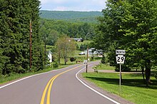
The road turns north and fully enters Marlborough Township, heading through wooded areas with some homes to the east of Green Lane Reservoir Park.
PA 29 leaves East Greenville for Upper Hanover Township and becomes Gravel Pike, passing between a shopping center to the southwest and farmland to the northeast.
[3][5] PA 29 enters Hereford Township in Berks County and runs past homes with some farms and woods in Chapel, curving to the north.
PA 29 continues past commercial development before it comes to a bridge over Norfolk Southern's Reading Line and curves to the east-northeast near homes and businesses.
PA 29 crosses into Salisbury Township and widens into a four-lane road that passes between Lehigh Valley Hospital–Cedar Crest to the west and an office park to the east.
The route becomes a divided highway and comes to an interchange with I-78/PA 309, where the southern section of PA 29 ends and Cedar Crest Boulevard becomes SR 1019, continuing north toward Allentown.
The route passes through wooded areas with some nearby development, coming to an interchange with Main Street that provides access to Ashley to the northeast and Sugar Notch to the southwest.
Following this interchange, the freeway heads through a corner of Sugar Notch before crossing back into Hanover Township and passing near several warehouses and some homes.
Following this, PA 29 passes over Norfolk Southern's Sunbury Line before it comes to a bridge over the Susquehanna River, at which point it crosses into Plymouth Township.
The road runs through forests with some fields and homes, entering Eaton Township and reaching a junction with the western terminus of PA 292.
The route becomes a two-lane undivided road again and crosses Bowman Creek on a truss bridge, passing to the east of Seneca Trail County Park.
The route gains a center left-turn lane and becomes Hunter Highway, passing businesses as it heads to the west of Skyhaven Airport.
The road continues through wooded areas with some fields and homes, passing to the west of Lake Carey and heading into Lemon Township.
In 1936, two major sections of the route, stretching between Evans Falls to Rosengrants, near Tunkhannock, and from Franklin Forks to the state line, were paved.
The slip ramps initially faced opposition from local residents, as they voiced concern as to the potential implications a turnpike connection would have on traffic in the area.
[16] Funding for the PA 29 slip ramp was approved in 2002,[17] but due to environmental concerns, design issues, and continued opposition, construction did not begin until March 2011.
[19] Following the turnpike's switch to toll-by-plate electronic toll collection in 2020, the interchange is no longer E-ZPass only, and is now open to non-E-ZPass tagholders.
[21] Pennsylvania Route 29 Truck signs are used to direct motorists from Egypt Road at the US 422 interchange to PA 29 in Upper Providence Township in Montgomery County.