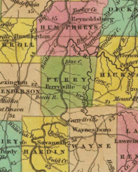
Perry County, Tennessee
[4] Arrowheads and spear tips associated the Mississippian, Woodland, and Copena cultures have been found along the Tennessee River tributaries in the western half of the county.
[5] One example of ancient Native American statuary, an 8 inches (20 cm) tall female figure unearthed prior to 1868 near a mound in the county, is in the collection of the Smithsonian Institution.
[6] On January 7, 1806, with the signing of the Treaty of Washington, the Cherokee ceded to the United States a large tract of territory in the south-central portion of Tennessee that included the area that would become Perry County.
Some of the early settlers were veterans of the War of 1812, and some had probably received land grants in the area from the state of North Carolina for service in the American Revolution.
[13] Early in its history, Perryville was a relatively important river port and settlement, with some sources noting David Crockett, Andrew Jackson, Sam Houston, and James K. Polk all having visited the town at some point.
[16][17][18] In February 1833, the issue of nullification, or the ability of state governments to unilaterally invalidate Federal laws as unconstitutional, was raised in a mass meeting in Perryville.
[10] During this time period, in 1844, the community of Flatwoods, originally known as Whitaker's Bluff, was established along the Buffalo River in the southern part of the county by a group of settlers from Halifax, North Carolina.
[26] In 1854, Lobelville was established as a trading-post village on the west bank of the Buffalo River about 5 miles (8.0 km) north of Beardstown by a French trader named Henri de Lobel.
[27] The total number of people killed by so-called vigilance committees is unclear, with contemporary reports citing as many as 15 being hanged,[28] and later historical research noting between 10 and 12.
[27] The issue of whether or not Perry County would swing towards Unionist or Secessionist causes was not clear as late as May 1861, when a pro-Union convention was held in Linden to nominate a Republican candidate for Congress.
[30] Even though the vote was overwhelmingly in favor of secession, the Unionist sentiment was strong and pervasive throughout the war, with men from the county volunteering for both sides in the conflict.
[10] One particularly notable Confederate unit formed in the county was Harder's Company of the 23rd Tennessee Infantry Regiment, raised in 1861 and composed of about 100 men from the Cedar Creek area.
This unit fought throughout the war, seeing action at Fort Donelson, Shiloh, Stones River, Chickamagua, and the Siege of Petersburg, after which they surrendered with the Army of Northern Virginia in 1865.
[33] Due to the rural, isolated nature of the region, away from the major railway lines and with only limited access to large landings on the Tennessee River, there were no large-scale engagements in the county.
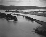
[36] In April 1863 the Mississippi Marine Brigade, a Union Army amphibious unit consisting of infantry and a number of gunboats, held at Britt's Landing after fighting further upriver before attempting to pass the shoals at the Duck River confluence.
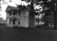
The farm, still owned by the Craig family, is listed in the National Register of Historic Places due to its significance in the history of black farmers in Tennessee.
While a terminus allowing the transfer of goods from rail to river shipping was constructed in Perryville, the bridge was never built and the railroad was never extended into Perry County.
The bridge, named after World War I Medal of Honor recipient Alvin C. York, was opened on July 5, 1930, by Governor Henry Horton as part of a major road building program to provide additional links between Memphis and Nashville.
Following this, businesses began to leave the county for locations nearer urban areas and adjacent to the highway; and when two garment factories and an automobile parts plant ceased operations, the conditions were set for long-term economic stagnation.
That year, the TVA offered to give 100 acres (40 hectares) of land to the state, and a matching Federal grant of $1.1 million had been made available for the park's development.
[79] In 1944, with the construction of Kentucky Dam, portions of low-lying land adjacent to the river were inundated, although the societal and environmental impact was substantially lower than areas farther downstream.
[82] One possibly apocryphal story of the origin of the name of the bluff stems from a supposed incident where a woman was kidnapped and used as bait for an ambush by Native Americans against white settlers encroaching on their land.
The water table is high due to the hard substrate, creating numerous springs and shallow wells, and is charged by the Highland Rim aquifer.
Cherty limestone deposits are the most extensive geologic feature of the county, and an impermeable siltstone and shale base below the chert formations has led to the emergence of numerous fresh water springs.
There are large populations of bobcat, opossum, gray fox, striped skunk, and coyote, as well as numerous species of reptiles, amphibians, and birds.
[122] In 2012, an auto parts supplier opened an injection molded plastics facility in a then-shuttered factory space in Linden, providing over 400 jobs to the local community and substantially relieving unemployment in the county.
The sheriff is responsible for all law enforcement functions, including crime prevention and investigation, apprehension of criminals, and patrolling the county's roads.
[150] In addition to the public general aviation airport, a private-use helipad (FAA identifier 5TN8) is located at the now-closed Perry Community Hospital in Linden.
Numerous locals appeared as extras in the lost film which chronicled the life of John Murrell, a bandit who operated in the area in the early 19th century.
[177] Perry County is served by a local health department that provides basic healthcare services, including vaccinations, disease testing, primary care, and pediatrics.