Philippines
In the western Pacific Ocean, it consists of 7,641 islands, with a total area of roughly 300,000 square kilometers, which are broadly categorized in three main geographical divisions from north to south: Luzon, Visayas, and Mindanao.
It shares maritime borders with Taiwan to the north, Japan to the northeast, Palau to the east and southeast, Indonesia to the south, Malaysia to the southwest, Vietnam to the west, and China to the northwest.
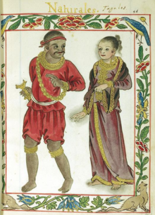
Extensive overseas trade with neighbors such as the late Tang or Song empire brought Chinese people to the archipelago as well, which would also gradually settle in and intermix over the centuries.
In 1543, Spanish explorer Ruy López de Villalobos named the archipelago Las Islas Filipinas in honor of King Philip II of Castile.
During his 1542 expedition, Spanish explorer Ruy López de Villalobos named the islands of Leyte and Samar "Felipinas" after the Prince of Asturias, later Philip II of Castile.
[29] Tabon Man is presumably a Negrito, among the archipelago's earliest inhabitants descended from the first human migrations out of Africa via the coastal route along southern Asia to the now-sunken landmasses of Sundaland and Sahul.
[37] Polities founded in the Philippines between the 10th and 16th centuries include Maynila,[49] Tondo, Namayan, Pangasinan, Caboloan, Cebu, Butuan, Maguindanao, Lanao, Sulu, and Ma-i.
[52] When the barangays banded together to form a larger settlement or a geographically looser alliance,[38]: 3 [53] their more-esteemed members would be recognized as a "paramount datu",[54]: 58 [35] rajah or sultan,[55] and would rule the community.
[75][76] During its rule, Spain nearly bankrupted its treasury quelling indigenous revolts[73]: 111–122 and defending against external military attacks,[77]: 1077 [78] including Moro piracy,[79] a 17th-century war against the Dutch, 18th-century British occupation of Manila, and conflict with Muslims in the south.
[92][93] This inspired the Propaganda Movement, organized by Marcelo H. del Pilar, José Rizal, Graciano López Jaena, and Mariano Ponce, which advocated political reform in the Philippines.
[135]: 38–41 [136] Efforts at post-war reconstruction and ending the Hukbalahap Rebellion succeeded during Ramon Magsaysay's presidency,[137] but sporadic communist insurgency continued to flare up long afterward.
[70]: 182 Succeeding Garcia, Diosdado Macapagal moved Independence Day from July 4 to June 12—the date of Emilio Aguinaldo's declaration—[139] and pursued a claim on eastern North Borneo.
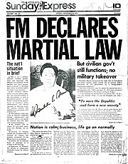
[142]: 58 [143] Near the end of his last constitutionally-permitted term, Marcos declared martial law on September 21, 1972[144] using the specter of communism[145][146][147] and began to rule by decree;[148] the period was characterized by political repression, censorship, and human rights violations.
[167][142]: xii, xiii A communist insurgency[168][169] and military conflict with Moro separatists persisted;[170] the administration also faced a series of disasters, including the eruption of Mount Pinatubo in June 1991.
[173][174] His successor, Joseph Estrada, prioritized public housing[175] but faced corruption allegations[176] which led to his overthrow by the 2001 EDSA Revolution and the succession of Vice President Gloria Macapagal Arroyo on January 20, 2001.
[177] Arroyo's nine-year administration was marked by economic growth,[10] but was tainted by corruption and political scandals,[178][179] including electoral fraud allegations during the 2004 presidential election.
[188][189] Among Duterte's priorities was aggressively increasing infrastructure spending to spur economic growth;[190][191] the enactment of the Bangsamoro Organic Law;[192] an intensified crackdown on crime and communist insurgencies;[193] and an anti-drug campaign that reduced drug proliferation[194] but that has also led to extrajudicial killings.
[213] The country's 11 largest islands are Luzon, Mindanao, Samar, Negros, Palawan, Panay, Mindoro, Leyte, Cebu, Bohol and Masbate, about 95 percent of its total land area.
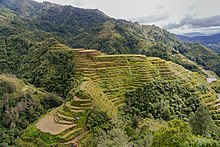
[264] Three sites in the Philippines have been included on the UNESCO World Heritage List: the Tubbataha Reef in the Sulu Sea,[265] the Puerto Princesa Subterranean River,[266] and the Mount Hamiguitan Wildlife Sanctuary.
[329][322] Japan is the biggest bilateral contributor of official development assistance to the Philippines;[330][331] although some tension exists because of World War II, much animosity has faded.
[357][358] Other, more-militant groups such as Abu Sayyaf and Bangsamoro Islamic Freedom Fighters[359] have kidnapped foreigners for ransom, particularly in the Sulu Archipelago[360][361] and Maguindanao,[359] but their presence has been reduced.
[370] The Philippines is a unitary state, with the exception of the Bangsamoro Autonomous Region in Muslim Mindanao (BARMM),[371] although there have been steps towards decentralization;[372][373] a 1991 law devolved some powers to local governments.
[386] With an average annual growth rate of six to seven percent since around 2010, the Philippines has emerged as one of the world's fastest-growing economies,[389] driven primarily by its increasing reliance on the service sector.
[417][418] Tourist spots include Boracay, called the best island in the world by Travel + Leisure in 2012;[419] Coron and El Nido in Palawan; Cebu; Siargao, and Bohol.
[460] Political issues following Marcos' ouster and safety concerns after the 1986 Chernobyl disaster prevented the plant from being commissioned,[461][459] and plans to operate it remain controversial.
[528] Census data from 2020 found that 78.8 percent of the population professed Roman Catholicism;[d] other Christian denominations include Iglesia ni Cristo, the Philippine Independent Church, and Seventh-day Adventism.
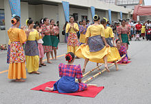
[593][594] Other Filipino values are optimism about the future, pessimism about the present, concern about other people, friendship and friendliness, hospitality, religiosity, respect for oneself and others (particularly women), and integrity.
[599][600] Other artists during Spanish colonial rule included painters such as Josef Luciano Dans, Jose Honorato Lozano, Mariano Asuncion[601] and sculptors such as Isabelo Tampinco and Crispulo Hocson.
[607][608] Spanish architecture left an imprint in town designs around a central square or plaza mayor, but many of its buildings were damaged or destroyed during World War II.
[642][643] In the late 1960s, during the presidency of Ferdinand Marcos, Philippine literature was influenced by political activism; many poets began using Tagalog, in keeping with the country's oral traditions.