Phoenix (spacecraft)
Academic and industrial partners included universities in the United States, Canada, Switzerland, Denmark, Germany, the United Kingdom, NASA, the Canadian Space Agency, the Finnish Meteorological Institute, Lockheed Martin Space Systems, MacDonald Dettwiler & Associates (MDA) in partnership with Optech Incorporated (Optech) and other aerospace companies.
The lander completed its mission in August 2008, and made a last brief communication with Earth on November 2 as available solar power dropped with the Martian winter.
However, the craft exceeded its expected operational lifetime[8] by a little over two months before succumbing to the increasing cold and dark of an advancing Martian winter.
[9] The mission was chosen to be a fixed lander rather than a rover because:[10] The 2003–2004 observations of methane gas on Mars were made remotely by three teams working with separate data.
Scientists from Imperial College London and the University of Bristol provided hardware for the mission and were part of the team operating the microscope station.
Commands were sent for the arm to be deployed on May 28, 2008, beginning with the pushing aside of a protective covering intended to serve as a redundant precaution against potential contamination of Martian soil by Earthly life-forms.
[36] On May 29, 2008 (sol 4), electrical tests indicated an intermittent short circuit in TEGA,[37] resulting from a glitch in one of the two filaments responsible for ionizing volatiles.
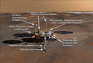
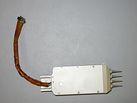
The Microscopy, Electrochemistry, and Conductivity Analyzer (MECA) is an instrument package originally designed for the canceled Mars Surveyor 2001 Lander mission.
Tufts University developed the reagent pellets, barium ISE, and ASV electrodes, and performed the preflight characterization of the sensor array.
The lidar collected information about the time-dependent structure of the planetary boundary layer by investigating the vertical distribution of dust, ice, fog, and clouds in the local atmosphere.
[citation needed] There are three temperature sensors (thermocouples) on a 1 m (3.3 ft) vertical mast (shown in its stowed position) at heights of approximately 250, 500 and 1,000 mm (9.8, 19.7 and 39.4 in) above the lander deck.
This first profile indicated well-mixed dust in the first few kilometers of the atmosphere of Mars, where the planetary boundary layer was observed by a marked decrease in scattering signal.
[70] The projected landing area was an ellipse 100 by 20 km (62 by 12 mi) covering terrain which has been informally named "Green Valley"[71] and contains the largest concentration of water ice outside the poles.
Mars Reconnaissance Orbiter's High Resolution Imaging Science Experiment (HiRISE) camera photographed Phoenix suspended from its parachute during its descent through the Martian atmosphere.
[80] The images show a surface strewn with pebbles and incised with small troughs into polygons about 5 m (16 ft) across and 10 cm (3.9 in) high, with the expected absence of large rocks and hills.
[81] Experiments conducted by Nilton Renno, mission co-investigator from the University of Michigan, and his students have investigated how much surface dust would be kicked up on landing.
In 2007, a report to the American Astronomical Society by Washington State University professor Dirk Schulze-Makuch, suggested that Mars might harbor peroxide-based life forms which the Viking landers failed to detect because of the unexpected chemistry.
[85] The polygonal cracking at the landing zone had previously been observed from orbit, and is similar to patterns seen in permafrost areas in polar and high altitude regions of Earth.
[86] Phoenix's robotic arm camera took an image underneath the lander on sol 5 that shows patches of a smooth bright surface uncovered when thruster exhaust blew off overlying loose soil.
[88][89] On June 19, 2008 (sol 24), NASA announced that dice-sized clumps of bright material in the "Dodo-Goldilocks" trench dug by the robotic arm had vaporized over the course of four days, strongly implying that they were composed of water ice which sublimed following exposure.
Additionally during 2008 and early 2009 a debate emerged within NASA over the presence of 'blobs' which appeared on photos of the vehicle's landing struts, which have been variously described as being either water droplets or 'clumps of frost'.
The salts would then have absorbed water vapor from the air, which would have explained how they appeared to grow in size during the first 44 sols (Martian days) before slowly evaporating as Mars temperature dropped.
The robotic arm scooped up more soil and delivered it to 3 different on-board analyzers: an oven that baked it and tested the emitted gases, a microscopic imager, and a wet chemistry laboratory (WCL).
[97] The lander's robotic arm scoop was positioned over the Wet Chemistry Lab delivery funnel on Sol 29 (the 29th Martian day after landing, i.e. June 24, 2008).
[120][121][122] To quell the speculation, NASA released the preliminary findings stating that Mars soil contains perchlorate (ClO4) and thus may not be as life-friendly as thought earlier.
Gullies, which are common in certain areas of Mars, may have formed from perchlorate melting ice and causing water to erode soil on steep slopes.
[130] Perchlorates have also been detected at the landing site of the Curiosity rover, nearer equatorial Mars, and in the martian meteorite EETA79001,[131] suggesting a "global distribution of these salts".
[131] Therefore, the MOMA instrument planned to fly on the 2022 ExoMars rover will employ a method that is unaffected by the presence of perchlorates to detect and measure sub-surface organics.
In 2006, The Planetary Society collected a quarter of a million names submitted through the Internet and placed them on the disc, which claims, on the front, to be "the first library on Mars.
"[134] This DVD is made of a special silica glass designed to withstand the Martian environment, lasting for hundreds (if not thousands) of years on the surface while it awaits retrieval by future explorers.


Phoenix · Sun · Earth · Mars


 Clickable image:
Clicking on the labels will open a new article.
Clickable image:
Clicking on the labels will open a new article.