Physical geography of the Basque Country
The territory hosts a blend of green and brown to yellowish tones, featuring hilly terrain altogether.
The Basque Country spreads from the rough coastal landscape to the semi-desert of the Bardenas on the south-eastern fringes of Navarre.
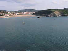
The main natural limits of the Basque Country are the Bay of Biscay (south-east of Cantabrian Sea) to the north and westside, and in the south side, the Ebro river.
When different rivers join the sea, small estuaries can be found (Oria), and in the others, maritime branches (Urumea, Bidasoa).
It is 910 km long, and flows along the southern boundary of the Basque Country before it joins the Mediterranean sea.
On its way east, the Ebro harvests the water of a string of tributaries, such as Zadorra, Baias, Ega and Aragon.
Aturri, which joins the sea in the coast of Basque Country, is the largest river and has the biggest water flow.
Like Aturri, other Basque rivers join the sea in the Bay of Biscay, such as Nerbioi, Bidasoa, Oria, Deba, Urola, and Urumea.
These breed of trees can be also found on the east of Álava, in the region called Mendialdea and Araialdea, and in Zuberoa and Lower Navarre.