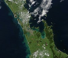
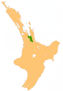
Hauraki Plains
They are located 75 kilometres south-east of Auckland, at the foot of the Coromandel Peninsula and occupy the southern portion of a rift valley bounded on the north-west by the Hunua Ranges, to the east by the Coromandel and Kaimai ranges and to the west by a series of undulating hills which separate the plains from the much larger plains of the Waikato River.
While there is no defined geographical southern boundary to the Hauraki Plains, this is generally taken as being a line between the towns of Te Aroha and Morrinsville, approximately following State Highway 26.
[6] Around 2–3 million years ago, a large block of the crust slumped down 500–2000 metres, forming in due course the Hauraki 2 to 3 half-grabens.
The plains were full of mangroves, raupō (Typha orientalis), harakeke (Phormium tenax) a dense forest of kahikatea.
Nevertheless, the rich flora and fauna of the plains amply provided the staples of the Māori people who lived in the region.
The colonists (or Pākehā) were timber millers such as the George and Martha Bagnall family who settled at Turua in 1875.
But, once a year, the Waihou and Piako Rivers would overflow, making agricultural settlement of the area difficult because of the poor drainage.
Ballots were held for the blocks, which attracted the interests of future settlers and businessmen in the Thames Valley.
Floodgates were installed to prevent the ingress of water into the canals, while allowing floodwaters to flow out of the system.
Once the land was mostly drained, scrub, logs and tree stumps had to be cleared, and the earth levelled, to convert it to pasture.
Larger passenger ships had luxurious lounges for men and women decorated with velvet upholstery and paintings on the walls.
Some cargo boats and punts were designed with drop sides to assist in loading and unloading on the river banks.
In 1877, massive timber ships called barques travelled up to Bagnalls' mill in Turua to collect the kahikatea logs and transport them to Auckland and Australia.
At Orchard (now called Ngatea), Pipiroa, Kopu and Paeroa there were punts (floating platforms) that carried people, horses and carts across the rivers for a small fee.
Before the arrival of the European settlers, the Hauraki Plains was 400 km2 of peat and swamp land which acted as a big ponding area, through which ran two main rivers – the Waihou and Piako.
Because the Hauraki Plains were swamp land and there were no roads the easiest way to transport people, supplies, food and produce was by boat.
There was even a special hard wharf built at Paeroa for fear of a conventional one collapsing while the machines were unloaded.
Huge barques (sailing ships) came up the river on flood tides to collect the wood, some of which would be taken to Australia and be made into butter boxes.
After the scrub and kahikatea had been cleared farming was taken up and the farmers needed everything from food to animals and boats and the rivers carried it all in.
Today it has all died away except the ferry that goes up the Waihou to Paeroa from Auckland, and the metal barge that comes into Kopu to pick up a load.
The Department of Conservation (DOC) estimates of wetlands that remain in the Waikato are around 320 km2, approximately 25% of their original area.
Five of New Zealand's wetlands are listed on the International Convention on Wetlands of International Importance (Ramsar sites); there are three of them in the Waikato Region: At 9,238.44 hectares, the Kopuatai Peat Dome is New Zealand's largest unaltered restiad peat bog, and is also globally unique.
The endangered Australasian bittern (Botaurus poiciloptilus) is found in the wetland with other endangered birds such as the banded rail (Rallus philipensis assimillis), marsh crake (Porzana pusilla affinis) and the North Island fernbird (Bowdleria punctata vealeae).