Pickens County, Chickasaw Nation
Pickens County was a political subdivision of the Chickasaw Nation in the Indian Territory from 1855, prior to Oklahoma being admitted as a state in 1907.
In 1850 the Choctaw Nation approved a constitutional change that enabled each of its four constituent districts to be divided into counties.
[5] A constitution promulgated on Aug. 30, 1856 established the new Chickasaw government and its counties of Panola, Pickens, Pontotoc and Tishomingo.
[8] A federal law designed to prepare the Five Civilized Tribes for eventual statehood, known as the Curtis Act, stripped the Chickasaw and other governments of meaningful powers after 1906.
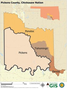
[9] Pickens County lay in the southwestern part of the Chickasaw Nation between the Washita and Red rivers.
Pickens County's location on the western edge of the domains of the Five Civilized Tribes left it exposed in its early years to external threats.
Depredations and threats from the Kiowa, Comanche and Apache Indians, whose reservations lay to the west, caused the U.S. Army to bolster frontier defenses.
Despite its sprawl and size, a well-designed transportation network was never developed in the county, and trails linked the settlements.
Three of the four counties were unusually large and geographically sprawling, possibly due to the relatively sparse population living there.
Pickens County posed similar challenges, stretching from the Chickasha area in the northwest to Madill in the southeast.
Following statehood the influx of settlers from the United States allowed for the region to be broken into smaller counties.