Port of San Francisco
[2] The port area under the commission's control comprises nearly eight miles of waterfront lands, commercial real estate and maritime piers from Hyde Street on the north to India Basin in the southeast.
The earliest development of a port in San Francisco, two and a half miles east of the Presidio, was under the Mexican regime, begun in 1835 as the town of Yerba Buena.
Whalers took umbrage at the taxes charged by the Mexican governor Manuel Micheltorena in 1843, and the outright banning of their trading in the port, then relocated from San Francisco to the Hawaiian Islands.
The United States governor of the newly occupied territory of California, General Stephen W. Kearny, renounced the rights of eminent domain of the American government in favor of the city of San Francisco.
When gold was discovered in California, the first hulk of an old iron revenue steamer, the James K. Polk, was beached at the foot of the bluff near Clarke's Point and became the foundation of the first real passenger landing in the city.
It was at this site that the population of San Francisco met the Pacific mail liner the Oregon to receive the official announcement that California had been admitted to the Union.
The bluff at the point was quickly leveled and on the land created a wharf was built that became the first regular berthing place, for a short time, for the Pacific mail steamships.
In the ensuing years, the state legislature passed bills concerning the sale of water lots and authorizing the city to construct wharves beyond its boundary and to set wharfage rates.
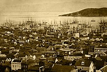
By 1851, the Central Wharf had ten times more business offered than it could handle, and many new wharves were struck into the bay, including those at Market, Sacramento, Washington, California, Clay, Jackson and Pacific Streets.
The filling of Yerba Buena Cove and extensive corruption and legislation led to a period, during the gold rush, when major portions of the city were built on water lots, reclaimed by hook or by crook, on pile driven and rough planking overlain.
Half the early city was built on trembling wharves and the scrub and sandy hills were not appreciated, amongst them only a few abodes and scattered tents were found.
Numerous other wharves, privately built and owned, stretched along the northern waterfront; Flint's, the India docks, Cowell's, Shaw's, Law's, Buckelew's, Cunnigham's and the Long Wharf.
Many of these wharves were on city lands that might be filled at any time, and most disappeared with the building of the Seawall and the modern piers built into the early 20th century.
Chapter 306 of the Statutes of 1863 created the California Board of State Harbor Commissioners and set about the task of building a Seawall on the San Francisco waterfront.
In 1890 the port commissioners began developing a series of switchyards and warehouses on the reclaimed land for use of the San Francisco Belt Railroad, a line of over 50 miles that connected every berth and every pier with the industrial parts of the city and railways of America with all the trade routes of the Pacific.
In 1912, the belt line was driven across Market Street in front of the Ferry Building to link the entire commercial waterfront with railways both south and north and across the continent.
The line was extended north along Jefferson Street through the tunnel to link up with U.S. Transport Docks at Fort Mason and south to China Basin.
Much of the Belt Railroad's right-of-way was removed following the 1989 Loma Prieta earthquake and replaced with streetcar tracks now used by the San Francisco Municipal Railway.
The Embarcadero (Spanish: Wharf) is the eastern waterfront and roadway of the Port of San Francisco constructed atop an engineered Seawall on reclaimed land.
Over 50 years a large offshore Seawall was built and the mudflats filled, creating what today is San Francisco's Financial District.
The Board of State Harbor Commissioners began extensive development along the waterfront, always meeting expenses from the revenues of the busy port.
In the 1920s, the emergence of Los Angeles as the West Coast's largest city—and in particular, as its major industrial center—relegated the Port of San Francisco to a secondary role.
Most of the Italian immigrant fishermen settled in the North Beach area close to the wharf and fished for the local delicacies and the now famed Dungeness crab.
One of the busiest and well known tourist attractions in the western United States, Fisherman's Wharf is best known for being the location of Pier 39, the San Francisco Maritime National Historical Park and its adjacent museum, the Cannery Shopping Center, Ghirardelli Square, a Ripley's Believe It or Not!
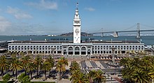
The San Francisco Ferry Building was built by the Harbor Commission for less than one million dollars and quickly became one of the most profitable investments in state history.
On either side of the ferry slips, bay and river steamers arrived and departed with passengers and produce to and from the Sacramento and San Joaquin Valleys.
In 2003, the building reopened after the restoration of major public spaces, as well as renovations for new uses: it has a re-dedicated ferry terminal, an upscale gourmet marketplace in the former baggage area featuring local goods, and upper floors adapted for office use.
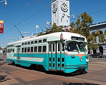
The F Market & Wharves line is operated as a heritage streetcar service, using exclusively historic equipment both from San Francisco's retired fleet as well as from cities around the world.
[13] The port of San Francisco owns extensive filled land at the Pier 70, San Francisco, California, Potrero Point district on the southeast bayfront at 20th Street east of Illinois that holds the greatest example of a 19th-century industrial village remaining in the western US, site of the first industrial iron and steel mills, shipbuilding and manufacturing center in California.
In 2006 the US Navy approached the city of San Francisco about permanently docking the retired USS Iowa as a floating museum and tourist attraction in Fisherman's Wharf.