Pierce Stocking Scenic Drive
The roadway, with its "scenic vistas and gentle curves",[3] is located off state highway M-109 between Empire and Glen Arbor.
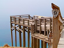
It runs for 7.4 miles (11.9 km) through forest and dunes areas, providing access to scenic overlooks of the Lake Michigan shoreline and the surrounding park land.
Interpretive markers along the roadway are keyed to the National Park Service's printed guide to the drive.
As the drive approaches this stop and the fourth, the Cottonwood Trail, it emerges from the forest into the sandy dune area next to Lake Michigan.
Several more stops are noted in the guide before Pierce Stocking Scenic Drive heads back inland through the beech and maple forest.
After this stop, the drive descends into maple and pine forests before coming back to the starting point.
[4] The drive has been called "the best way to see Lake Michigan from top of the dune elevations",[6] and "one of the nation's most fascinating landscapes".
A free interpretive guide for the scenic drive is available at the visitor center in Empire or at the entrance gate.
[1] According to National Geographic, Stocking was "so awed by the beauty of the dunes that ... he built the road in order to share them with visitors.
[15] At the time, it was named the Philip A. Hart Nature Trail after the senator, who backed the creation of the national lakeshore.
[16] The name was later changed to Pierce Stocking Scenic Drive in honor of the roadway's creator on November 1, 1979.
Stocking built the covered bridge, but the "NPS has maintained it and increased its vertical clearance to 13 feet 6 inches [4.11 m].