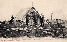
Pierre-sur-Haute military radio station
[1]: 01:48–01:55 In April 2013, the French interior intelligence agency DCRI pressured the president of Wikimedia France, Rémi Mathis, into deleting the French-language Wikipedia article about the station.
[1]: 05:03–05:35 In 1961, during the Cold War, NATO asked the French Army[1]: 05:35–05:40 to build the station as part of the 82-node transmission network in Europe known as the ACE High system.
[3] The NATO radio station was using American-made tropospheric scatter equipment to relay voice and telegraph signals on a network stretching from Turkey to the Arctic Polar Circle in Norway.
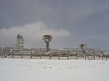
[5] The telecommunication tower is topped by a radome and contains a mode S air traffic control radar beacon system owned by the Directorate General for Civil Aviation.
[1]: 09:00-10:30 They are linked together by tunnels, 400 metres (1,300 ft) in total length,[1]: 12:00-12:10 so as to avoid walking through thick snow in winter when moving from one building to the other.
[1]: 09:50–10:03 The most important part of the site is the underground section, used for transmissions dispatch: at a speed of 2 Mb/s,[1]: 17:43 communications from the towers are analysed, then redirected to be transmitted.
[1]: 20:45–22:30 In March 2013, the French interior intelligence agency DCRI made a request for deletion of the French-language Wikipedia article about the site, titled Station hertzienne militaire de Pierre-sur-Haute.
[10][11] The DCRI then forced Rémi Mathis, a volunteer administrator of the French-language Wikipedia and president of Wikimedia France, under threat of detention and arrest, to delete the article.