Domenico and Francesco Pizzigano
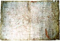
The Pizzigani brothers are principally known for the construction of a portolan chart, signed and dated 1367, currently held by the Biblioteca Palatina of Parma (Ms.Parm.1612).
[1] It was customary to refer to the brothers as the Pizigani (one z), until the discovery of the 1424 map of Zuane Pizzigano in the 20th century suggested a re-spelling to a double z.
[3] Some scholars, especially in the 19th century, believed this Atullia was the first reference to "Antillia" on a map (e.g. Buache, Kretschmer, Nordenskiöld)[4] but this reading has been doubted since.
The Pizzigani brothers called it the "Palolus" river, and place its source at a large lake in the "Mountains of the Moon" in the east (from which the Egyptian Nile was also believed to stem).
[10] The Pizzigani show the river running west, pouring into the Atlantic Ocean somewhere south of "Caput finis Gozola" (Cape Non).

