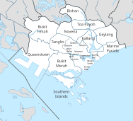
Planning areas of Singapore
Planning areas, also known as DGP areas or DGP zones, are the main urban planning and census divisions of Singapore delineated by the Urban Redevelopment Authority.
[5] Since implementing these boundaries, other government ministries and departments have increasingly adopted them for administrative purposes.
For example, the Statistics Department of Singapore published its 2000 census data based on planning area boundaries for the first time, compared to using census divisions based on electoral boundaries for previous exercises.
[6] The Singapore Police Force's (SPF) neighbourhood police centres have jurisdiction boundaries based on planning area boundaries when they were officially gazetted in 1999, as opposed to electoral divisions under the previous neighbourhood Police Post system.
Planning areas are further subdivided into 332 subzones for statistical purposes.