Platte River
The Platte is one of the most significant tributary systems in the watershed of the Missouri, draining a large portion of the central Great Plains in Nebraska and the eastern Rocky Mountains in Colorado and Wyoming.
The first Europeans to see the Platte were French explorers and fur trappers about 1714; they first called it the Nebraskier (Nebraska), a transliteration of the name given by the Otoe people, meaning "flat water".
The rugged Rocky Mountains Continental Divide surrounding Jackson County have at least twelve peaks over 11,000 feet (3,400 m) in height.
Today, by the time the North Platte reaches Paxton, Nebraska it is much smaller due to the extensive water taken from it for irrigation.
[6] The South Platte drains a large part of the Front Range mountains east of the continental divide.
After the South and Middle fork join, the South Platte flows east-southeast till it exits Elevenmile Reservoir; it turns almost ninety degrees to skirt the west side of Pikes Peak and flows roughly east-northeast about 100 miles (160 km) through Denver and on to Greeley, Colorado.
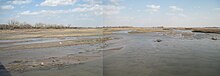
Its many shallow channels and islands and ever-changing sandbars made navigation difficult; it was never used as a major water transportation route.
The Platte flows in a large arc, east-southeast to near Fort Kearny and then east-northeast, across Nebraska south of Grand Island and on to Columbus.
From Columbus, the Platte flows almost due east about 50 miles (80 km) past North Bend and then on to Fremont.
The Platte drains one of the most arid areas of the Great Plains with a flow that is considerably lower than rivers of comparable length in North America.
For much of its length, it is a classic wide, muddy and shallow braided stream which in the lower reaches flows in a floodplain bordered by bluffs.
[11] During pioneer days, the common humorous description was that the Platte was "a mile wide at the mouth, but only six inches deep."
In western Nebraska, the banks and riverbed of the Platte provide a green oasis amid an otherwise semi-arid region of North America.
[13] Occupied by various Indian tribes for part of each year, the Platte River territory had been claimed by both Spanish and French explorers trying to rule the Great Plains.
Long reported the area as a great American desert, despite its native inhabitants and wildlife, due to a lack of easily-cultivated land.
In 1824 fur trappers and traders directing mule trains carrying trade goods and supplies for the mountain men were some of the first European-American parties to use the trail.
In 1834 Benjamin Bonneville, a U.S. Army officer on leave, led an expedition to the west financed by John Jacob Astor.
The Platte River valley provided an easily passable wagon corridor; it sloped gradually up in height as it went almost due west from the Missouri.
[15] Long Native American use had created trails on both sides of the muddy, about 1 mile (1.6 km) wide and shallow Platte River.
The influx of so many emigrants strained the local ecosystem, to the point that in 1846, chief They Fear Even His Horses demanded compensation from the President of the United States (referred to as tȟuŋkášila, the Great Father) for the damage Americans caused to the Platte.
[16] The Pony Express, operational from 1860–61, and the First Transcontinental Telegraph, completed in 1861, both followed the earlier emigrant trails along the Platte.
In 1866 the Union Pacific portion of the first Transcontinental Railroad was constructed along the Platte River as it started west from Omaha.
In March 1924, the U.S. Army Air Corps conducted a three-day bombing campaign on an ice gorge that threatened bridges near the town of North Bend.
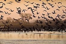
[17] The Platte is in the middle of the Central Flyway,[18] a primary north–south corridor for migratory birds from their summer nesting grounds in the north (Alaska and Canada), south for the winter, and the return in the spring.
Common plants in the Platte River area are big and little bluestem, switch grass, and cottonwood trees.
The Platte River area has long supported many animals but recently, due to urbanization and farming causing loss of habitat, the numbers have declined.
Under Nebraska law, a river basin, subbasin, or reach shall be deemed overappropriated if it is subject to an interstate cooperative agreement among more states and if, prior to such date, the state has declared a moratorium on the issuance of new surface water appropriations in such river, subbasin, or reach, and has requested each natural resources district jurisdiction in the affected area to close or continue in effect a previously adopted closure of part of such river basin, subbasin, or reach to the issuance of additional water well permits, or to temporarily suspend or continue in effect a temporary suspension previously adopted on the drilling of new water wells in all or part of such river basin, subbasin, or reach.
Beginning in 2004, a number of Nebraska stakeholders embarked upon the Platte River Cooperative Hydrology Study (COHYST).
This improved understanding could be used to develop policies for management of the river system, both for human use and for the sake of the basin's endangered species.