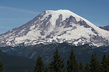
Mount Rainier
[2] On clear days it dominates the southeastern horizon in most of the Seattle-Tacoma metropolitan area to such an extent that locals sometimes refer to it simply as "the Mountain".
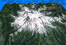
[44] The National Park Service and United States Geological Survey cite Mount Rainier's elevation at the Columbia Crest as 14,410 ft (4,392 m).
Rainier likely once stood even higher than today at about 16,000 ft (4,900 m) before a major debris avalanche and the resulting Osceola Mudflow approximately 5,000 years ago.
Around 5,000 years ago, a large chunk of the volcano slid away and that debris avalanche helped to produce the massive Osceola Mudflow, which went all the way to the site of present-day Tacoma and south Seattle.
[46] Soils on Mount Rainier are mostly gravelly ashy sandy loams developed from colluvium or glacial till mixed with volcanic tephra.
Many of the above are dormant, but could return to activity, and scientists on both sides of the border gather research of the past eruptions of each in order to predict how mountains in this arc will behave and what they are capable of in the future, including Mount Rainier.
According to Geoff Clayton, a geologist with a Washington State Geology firm, RH2 Engineering, a repeat of the 5000-year-old Osceola Mudflow would destroy Enumclaw, Orting, Kent, Auburn, Puyallup, Sumner and all of Renton.
[49] Such a mudflow might also reach down the Duwamish estuary and destroy parts of downtown Seattle, and cause tsunamis in Puget Sound and Lake Washington.
[63] A 2012 Washington State Department of Natural Resources estimate showed that a significant lahar could cause up to $40 billion in damage downriver.
[67] More recently (since 2001) funding from the federal government for lahar protection in the area has dried up, leading local authorities in at-risk cities like Orting to fear a disaster similar to the Armero tragedy.
[68][69] To prevent against such tragedies, authorities downriver from Rainier have conducted annual large-scale evacuation exercises in cooperation with local school districts.
[70] During the exercise, emergency operations centers in the cities of Puyallup, Bonney Lake, and Buckley were activated to help the movement of school students and staff.
They erode the volcanic cone and are important sources of streamflow for several rivers, including some that provide water for hydroelectric power and irrigation.
[76][77][33][34] Glaciers flow under the influence of gravity by the combined action of sliding over the rock on which they lie and by deformation, the gradual displacement between and within individual ice crystals.
Flow rates are generally greater in summer than in winter, probably due to the presence of large quantities of meltwater at the glacier base.
For example, during the last ice age, from about 25,000 to about 15,000 years ago, glaciers covered most of the area now within the boundaries of Mount Rainier National Park and extended to the perimeter of the present Puget Sound Basin.
[79] Using satellite data in 2022, researchers at Nichols College determined that both Pyramid and Van Trump glaciers had also ceased to exist with only fragments of ice remaining.
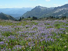
Their distribution on the mountain suggest primary use of subalpine meadows and low alpine habitats that provided relatively high resource abundance during the short summer season.
[85] Evidence suggests that there existed a tradition of Native Americans setting fire to areas of the region each year as a way to encourage meadow development.
[87] This claim to the coast of the Pacific Northwest was not further explored until in 1778 Captain James Cook sailed the coastline of modern-day Washington and British Columbia, stimulating a subsequent increase in English ships coming to the area as part of the fur trade.
[87] On July 22, 1793, Sir Alexander Mackenzie of the British Northwest Fur Company reached the Pacific Ocean via overland route that crossed the Rocky Mountains.
[87] In 1853, the land between the Columbia river and the border with British Canada was organized into the Washington Territory, which was the administrative status of the region at the time of the first successful ascent of Mount Rainier.
In 1893, the area was set aside as part of the Pacific Forest Reserve in order to protect its physical and economic resources, primarily timber and watersheds.
[95] Citing the need to also protect scenery and provide for public enjoyment, railroads and local businesses urged the creation of a national park in hopes of increased tourism.
[98] In 1998, the United States Geological Survey began putting together the Mount Rainier Volcano Lahar Warning System to assist in the emergency evacuation of the Puyallup River valley in the event of a catastrophic debris flow.
[111] The worst mountaineering accident on Mount Rainier occurred in 1981, when ten clients and a guide died in an avalanche/ice fall on the Ingraham Glacier.
[112] This was the largest number of fatalities on Mount Rainier in a single incident since 32 people were killed in a 1946 plane crash on the South Tahoma Glacier.
[113] In one of the worst disasters on the mountain in over thirty years, six climbers—two guides, and four clients—were killed on May 31, 2014, after the climbers fell 3,300 feet (1,000 m) while attempting the summit via the Liberty Ridge climbing route.
Searchers found tents and clothes along with rock and ice strewn across a debris field on the Carbon Glacier at 9,500 ft (2,900 m), possible evidence for a slide or avalanche in the vicinity where the team went missing, though the exact cause of the accident is unknown.
[123] The mountain supports a wide variety of animal life, including several species that are protected on the state or federal level, like the northern spotted owl.

![[[N767BA]], the first 767 built (the prototype), in flight over Mount Rainier, circa 1980s](http://upload.wikimedia.org/wikipedia/commons/thumb/6/62/Boeing_767_over_Mount_Rainier%2C_circa_1980s.jpg/220px-Boeing_767_over_Mount_Rainier%2C_circa_1980s.jpg)