Pole of inaccessibility
In geography, a pole of inaccessibility is the farthest (or most difficult to reach) location in a given landmass, sea, or other topographical feature, starting from a given boundary, relative to a given criterion.
In these cases, a pole of inaccessibility is the center of a maximally large circle that can be drawn within an area of interest only touching but not crossing a coastline.
It is not clear who first defined this point, but it may have been Sir Hubert Wilkins, who wished to traverse the Arctic Ocean by aircraft in 1927.
In 1968 Sir Wally Herbert came very close to reaching what was then considered to be the position by dogsled, but by his own account, Across the Top of the World, did not make it due to the flow of sea ice.
[citation needed] In 2005, explorer Jim McNeill asked scientists from The National Snow and Ice Data Center and Scott Polar Research Institute to re-establish the position using modern GPS and satellite technology.
The discrepancies are due to the question of whether the "coast" is measured to the grounding line or the edges of ice shelves, the difficulty of determining the location of the "solid" coastline, the movement of ice sheets and improvements in the accuracy of survey data over the years, as well as possible topographical errors.
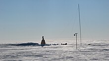
On 14 December 1958, the 3rd Soviet Antarctic Expedition for International Geophysical Year research work, led by Yevgeny Tolstikov, established the temporary Pole of Inaccessibility Station (Russian: полюс недоступности, polyus nedostupnosti) at 82°6′S 54°58′E / 82.100°S 54.967°E / -82.100; 54.967 (Pole of Inaccessibility Station).
Today, a building still remains at this location, marked by a bust of Vladimir Lenin that faces towards Moscow, and protected as a historical site.
On 11 December 2005, at 7:57 UTC, Ramón Hernando de Larramendi, Juan Manuel Viu, and Ignacio Oficialdegui, members of the Spanish Transantarctic Expedition, reached for the first time in history the southern pole of inaccessibility at 82°53′14″S 55°4′30″E / 82.88722°S 55.07500°E / -82.88722; 55.07500 (British Antarctic Survey-accredited Pole of Inaccessibility), updated that year by the British Antarctic Survey.
Both achievements took place within an ambitious pioneer crossing of the eastern Antarctic Plateau that started at Novolazarevskaya Station and ended at Progress Base after more than 4,500 km (2,800 mi).
[13][14][15][16] On 4 December 2006, Team N2i, consisting of Henry Cookson, Rupert Longsdon, Rory Sweet and Paul Landry, embarked on an expedition to be the first to reach the historic pole of inaccessibility location without direct mechanical assistance, using a combination of traditional man hauling and kite skiing.
The team reached the old abandoned station on 19 January 2007, rediscovering the forgotten statue of Lenin left there by the Soviets some 48 years previously.
[22] The problem entails finding such a place in the world ocean where, if a person fell overboard while on a ship at sea, they would be as far away from any land in any direction as possible.
It lies in the South Pacific Ocean, and is equally distant from the three closest land vertices which are each roughly 2,688 km (1,670 mi) away.
[22] The area is so remote that, since no regular marine or air traffic routes are within 400 kilometres (250 mi), sometimes the closest human beings are astronauts aboard the International Space Station when it passes overhead.
[23] To the west the region of the South Pacific Ocean is also the site of the geographic center of the water hemisphere, at 47°24′42″S 177°22′45″E / 47.411667°S 177.379167°E / -47.411667; 177.379167 near New Zealand's Bounty Islands.
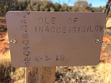
[1] These points lie in a close triangle about the Dzungarian Gate, a significant historical gateway to migration between the East and West.
EPIA2 is located near a settlement called K̂as K̂îr Su in a region named K̂îzîlk̂um (قىزىلقۇم) in the Karamgay Township [zh], Burultokay County.
[32] In 2019, it was discovered that there is a second South American pole of inaccessibility to the north, its position varying greatly between the two coastline datasets used.
Currently used datasets are the GSHHG (Global Self-consistent, Hierarchical, High-resolution Geography Database)[33] as well as OpenStreetMap (OSM) planet dumps.
The GSHHG claims 500-meter precision for 90% of identifiable coastal features, while the volunteer-build OSM give no such guarantee but nevertheless "have characteristics suggesting accuracy".