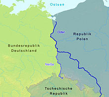
Germany–Poland border
The Germany–Poland border traces its origins to the beginnings of the Polish state, with the Oder (Odra) and Lusatian Neisse (Nysa) rivers (the Oder–Neisse line) being one of the earliest natural boundaries of the early Polish state under the Piast dynasty,[2][3][4] although not necessarily yet a border with Germany, as present-day north-eastern Germany was still inhabited by Slavic Lechitic tribes, and German conquests and sovereignty over the tribes were periodic and intermittent.
Polish victories against invading German forces at Cedynia (972) and Niemcza (1017) secured the early western border of Poland.
[18][19][20] Soviet foreign minister Vyacheslav Molotov, replied to Mikołajczyk's question about the western border of Poland that "it should be based on the Oder River".
At the summit in Yalta, the leaders of the powers decided to hand over to Poland part of East Prussia with Olsztyn and Elbląg, Pomerania with Gdańsk and Szczecin, Lower and Upper Silesia with Opole, Wrocław and Gliwice, and eastern Lubusz Land.
On July 24, for the only time in history, the communist Bierut and the oppositionist Stanisław Mikołajczyk spoke with one voice, fighting for the Oder and Western Neisse line.
Churchill insisted on Eastern Neisse, which meant that Wałbrzych with its region and Jelenia Góra would remain German.
Just before the final protocol was signed, Soviet diplomats made one more amendment according to which the border was to run "west of Świnoujście".
It was already established in September 1945 that Poland would depart from the German side of Rieth [de; pl] and Altwarp in exchange for Stolec, Buk, Bobolin, Barnisław, Rosówek, Pargowo and the Stobno-Kołbaskowo road.
In November 1950, the government of East Germany agreed to the transfer of a water intake to Poland, located at Lake Wolgastsee.
In return, a similarly sized area north of Mescherin, including the village of Staffelde (Polish: Staw), was transferred from Poland to the German Democratic Republic.