Territorial evolution of Poland
Poland is a country in Central Europe[1][2] bordered by Germany to the west; the Czech Republic and Slovakia to the south; Ukraine, Belarus, and Lithuania to the east; and the Baltic Sea and Kaliningrad Oblast, a Russian exclave, to the north.
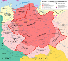
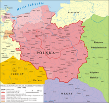
From a nucleus between the Oder and Vistula rivers on the North-Central European Plain, Poland has at its largest extent expanded as far as the Baltic, the Dnieper and the Carpathians, while in periods of weakness it has shrunk drastically or even ceased to exist.
The Commonwealth's political system, often called the Noble's Democracy or Golden Freedom, was characterized by the sovereign's power being reduced by laws and the legislature (Sejm), which was controlled by the nobility (szlachta).
[26] In 1013, the marriage between Bolesław's son Mieszko and Richeza of Lotharingia, the niece of Emperor Otto III and future mother of Casimir I the Restorer, took place.
After returning from exile in 1039, Duke Casimir I (1016–1058), properly known as the Restorer, rebuilt the Polish monarchy and the country's territorial integrity through several military campaigns: in 1047, Masovia was taken back from Miecław, and in 1050 Silesia from the Czechs.
Szczecin was subdued in a bloody takeover and Western Pomerania up to Rügen (Polish: Rugia), except for the directly incorporated southern part, became Bolesław's fief,[33] to be ruled locally by Wartislaw I, the first duke of the Griffin dynasty.
[39] Brandenburg further expanded by gradual annexation of north-western Greater Poland, including Wałcz, Drezdenko and Kalisz Pomorski in 1296, Międzyrzecz in 1297 and Czaplinek by c. 1300.
A more extensive unification of Polish lands was accomplished by a foreign ruler, Wenceslaus II of Bohemia of the Přemyslid dynasty, who married Przemysł's daughter and became King of Poland in 1300.
[43] However, despite formal papal consent for the coronation, Władysław's right to the crown was disputed by successors of Wenceslaus III (a king of both Bohemia and Poland) on the Bohemian throne.
[44][45][46][47] After the 1319 extinction of Ascanian margraves of Brandenburg, the previously lost Lubusz Land and New March were the subject of rivalry between the Piasts (dukes of Jawor, Żagań and King Władysław I the Elbow-high), Griffins of Pomerania, the Ascanians of Saxe-Wittenberg and the Wittelsbachs of Bavaria until 1326, with Polish dukes capturing portions of the region at various times, but not permanently, except for the Międzyrzecz castellany which was decisively restored to the Kingdom of Poland.
[76] In the Treaty of Oliva, the Polish King, John II Casimir, renounced his claims to the Swedish crown, which his father Sigismund III Vasa had lost in 1599.
[88] Kosciuszko's insurgent armies, who fought to regain Polish territory, won some initial successes but they eventually fell before the forces of the Russian Empire.
Volunteer Polish legions attached themselves to Bonaparte's armies, hoping that in return the emperor would allow an independent Poland to reappear out of his conquests.
After the Battle of Wagram, the ensuing Treaty of Schönbrunn allowed for a significant expansion of the Duchy's territory southwards with the regaining of once-Polish and Lithuanian lands.
Following Napoleon's failed invasion of Russia, the duchy was occupied by Prussian and Russian troops until 1815, when it was formally partitioned between the two countries at the Congress of Vienna.
From the defeated German Empire, Poland received the following: On July 17, 1919, a ceasefire was signed in the Polish–Ukrainian War with the West Ukrainian People's Republic (ZUNR).
[104] The Free City of Danzig (Gdańsk) was created on 15 November 1920[105][106] in accordance with the terms of Article 100 (Section XI of Part III) of the 1919 Treaty of Versailles.
The Poles, exhausted, constantly pressured by the Western governments and the League of Nations, and with its army controlling the majority of the disputed territories, were willing to negotiate.
However, in his secret report to the 9th Conference of the Bolshevik Party on 20 September 1920, Lenin called the outcome of the war "In a word, a gigantic, unheard-of defeat",[112] considering he wanted to reach the German communist revolutionaries to aid them and establish a socialist marxist republic there.
By the time armistice was declared, most of the border was agreed except for three small politically and economically sensitive areas with both Polish and Czechoslovak residents: Cieszyn, Orawa, and Spisz.
[116] The Conference of Ambassadors decided that Czechoslovakia would cede to Poland a number of villages from the Orawa and Spisz regions, including the municipalities of Oravy Srnie, Podvlk, Harkabúz, Nižná Zubrica, Vyšná Zubrica, Oravka, Bukovina-Podsklie, Pekelník, Jablonka, Chyžné, Hladovka, Suchá Hora, Vyšná Lipnica, a part of Nižné Lipnice and 4.2% of the rather Belá new communities, with Fridman (Falštin settlement), Krempach, Tribš, Durštín, Čierna Hora, Jurgov, Repiská, Vyšné lapse, Nižné lapse, Nedeca, Kacvín and Lapšanka.
On the basis of the reports of this commission and those of its experts, in October 1921 the Council awarded the greater part of the Upper Silesian industrial district to Poland.
The conflict was only resolved by the Council of the League of Nations' Permanent Court of International Justice on March 12, 1924, which decided that Czechoslovakia should retain the territory of Javorzyna.
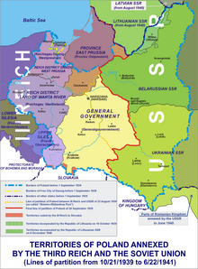
[124] After the invasion, Germany annexed the lands it lost to reformed Poland in 1919–1922 by the Treaty of Versailles: the Polish Corridor, West Prussia, the Province of Posen, and parts of eastern Upper Silesia.
The Polish territories east of the Curzon Line (known as the Kresy), which the Soviet Union had occupied in 1939 along with the Bialystok region were permanently annexed, resulting in Poland losing over 20% of its pre-war borders.
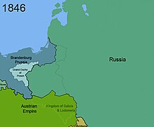
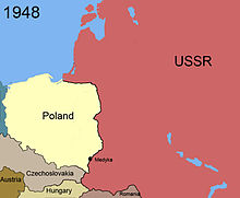
Poland also received the town of Swinemünde (now Świnoujście) on the island of Usedom and the city of Stettin (now Szczecin) on the western bank of the Oder river in accordance with the Potsdam Agreement.
[130] After the Second World War the Czechoslovak government wanted to return to the 1920 border between the two nations, while Polish inhabitants of Trans-Olza were in favour of the boundary of August 31, 1939.
The Czechs demanded former German areas of Kłodzko, Głubczyce, and Racibórz, but after Soviet mediation, all sides signed a treaty on September 21, 1945, which accepted the December 31, 1937, Polish–Czechoslovak and Czechoslovak–German borderline as the boundary between the two countries.
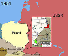
In return, a similarly-sized area north of Mescherin, including the village of Staffelde (Polish: Staw), was transferred from Poland to the German Democratic Republic.
c) in the Slovak village Skalité region with an area of 304 m2, according to documents limit referred to in Article 1, paragraph 4, including real estate, equipment and plants are transferred to the ownership of the Republic of Poland.