Port Macquarie
[6] Before British colonisation, large clans of Birpai people resided in and around Port Macquarie, particularly at places such as King's Creek, Blackman's Point, Camden Haven and Rolland's Plains.
They lived in large domed huts which provided protection against the region's heavy rains and were capable of accommodating up to ten people.
[7] The first documented visit to the site of Port Macquarie by the British was in 1818 when an expedition led by John Oxley reached the Pacific Ocean from the interior, after his journey to explore inland New South Wales.
[8] Oxley noted that "the natives in the vicinity of the port appeared very numerous...were all handsome, well-made men, stout in their persons, and showing evident signs of good living...were evidently acquainted with the use of firearms...their dread of its appearance", and that "the port abounds with fish, the sharks were larger and more numerous than I have ever before observed...the forest hills and rising grounds abounded with large kangaroos and the marshes afford shelter and support to innumerable wildfowl.
"[8] In 1821, Port Macquarie was founded as a penal settlement, replacing Newcastle as the destination for convicts who had committed secondary crimes in New South Wales.
[7] Port Macquarie, however, with its thick bush, tough terrain, large military presence and Indigenous Australians such as Bob Barrett (also called Monunggal) who were employed as 'bush constables' returning escaped prisoners for tobacco and blankets, provided large amounts of both isolation and hard labour to keep the criminals in control.
Under the various commandants, such as Francis Allman who was fond of flogging, the convicts had limited liberties and punishments regularly included whippings of up to 50 lashes at a time and hard labour in double leg irons.
The commanders of the settlement were:[7] During the 1820s, merchants such as Simeon Lord and Solomon Wiseman utilised the convict labour to extract large amounts of cedar and rosewood timber upriver from Port Macquarie.
[10] This colonial government funded plantation worked by convict labourers was later expanded to the nearby Rollands Plains and Ballengarra areas under the management of Thomas A. Scott.
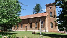
[7] St Thomas's Anglican Church is a Georgian building designed by Francis Greenway and built, under the supervision of military engineer Lieutenant T. Owen, by convicts from 1824 to 1828.
[7] In 1823, an exploratory party of soldiers shot down two groups of Aboriginal people near Telegraph Point and Ballengarra, causing those who survived to afterwards have great fear of the redcoats.
[13][14] In 1830, a stockman was killed by Aboriginal people at Rollands Plains, leading the commandant at the time, Captain Henry Smyth, to issue an edict prohibiting 'the natives' from carrying anything resembling weapons near the British settlements on pain of death.
[7] A town plan of Port Macquarie was produced by F. R. D'Arcy in 1831 and most of the first allotments were given out in the same year to military men associated with the penal colony such as Lieutenant Matthew Mitchell and Major A.C.
[18] In 1974, residents of Port Macquarie requested that the Builders Labourers Federation place a green ban against the construction of high rise buildings on beach head and water front.
[36] The residential suburbs stretch to Lighthouse Beach in the south, Thrumster to the west and to North Shore, on the northern bank of the river.
One of Australia's largest internet finance comparison websites, Credit Card Compare, now called Finty, was founded in Port Macquarie by Andrew and David Boyd.
The district is the site of two arterial roads which provide a direct link between Lighthouse Beach and Port Macquarie CBD.
Sovereign Hills is a newer development in Port Macquarie, between the locality of Thrumster to the east, and the Pacific Highway to the west.
Sea Acres National Park is adjacent to Shelly Beach and contains a visitor centre with access controlled rainforest boardwalk.
In winter and spring, the town can occasionally be affected by foehn winds due to its leeward position of the Great Dividing Range.
According to the CSIRO, Port Macquarie was considered the best climate in Australia due to its mild winters and pleasant summers, and also for its warm water for most of the year that is suited for swimming.
[51] The town is served by these local newspapers: Preschools/child care Three universities and TAFE offer a range of courses in Port Macquarie, as well as other vocational institutions.
However, the Port Macquarie CBD and northern suburbs are served by the nearby Wauchope railway station (17 km west of town), and the southern suburbs including satellite towns of Lake Cathie and Laurieton are served by Kendall railway station (30 km [19 mi] southwest).
Both stations are on the North Coast Line operated by NSW TrainLink with three services daily in each direction towards either Sydney or northwards to Grafton, Casino and Brisbane.