Port of Hong Kong
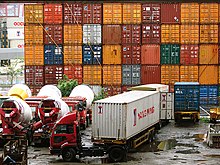
The Port of Hong Kong located by the South China Sea, is a deepwater seaport dominated by trade in containerised manufactured products, and to a lesser extent raw materials and passengers.
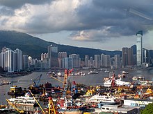
A key factor in the economic development of Hong Kong, the natural shelter and deep waters of Victoria Harbour provide ideal conditions for berthing and the handling of all types of vessels.
The Marine Department is responsible for ensuring that conditions exist to enable ships to enter the port, work their cargoes and leave as quickly and as safely as possible.
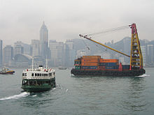
It is concerned with many aspects of safety standards for all classes and types of vessels, from the largest oil-carrying tankers to the smallest passenger-carrying sampans.
It also maintains aids to navigation and mooring buoys for seagoing ships, manages three cross-boundary ferry terminals and administers eight public cargo working areas.
Hong Kong is one of several hub ports serving the South-East and East Asia region, and is an economic gateway to mainland China.
The port is part of the Maritime Silk Road that runs from the Chinese coast via the Suez Canal to the Mediterranean, there to the Upper Adriatic region of Trieste with its rail connections to Central and Eastern Europe.
[9] Planning is underway for a potential Container Terminal 10 (CT10), with possible sites narrowed down to either southwest Tsing Yi or northwest Lantau, to the west of the airport.
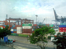
The 65-hectare terminal, completed in November 1999, has about 3,000 meters of quay, according to Hong Kong Port Development Council data.
Due to high handling fees at the container terminals, Hong Kong has become the only place in the world with at-sea loading and unloading operations.
The areas and water depths of the anchorages are diversified to accommodate different sizes and draughts of ships calling at Hong Kong.
It provides the latest technology such as AIS, ECDIS, CCTV, new VHF-direction finders and modern communications systems to further improve navigation safety and operation efficiency.
Marine Department patrol launches maintain a watch on shipping, traffic separation schemes, fairways, navigational channels, typhoon shelter and cargo-working areas.
The Hydrographic Office of the Marine Department surveys Hong Kong waters and produces nautical charts to facilitate safe navigation within the port.
A Differential Global Positioning System correction signal is broadcast continuously on 289 kHz to assist mariners using GPS navigation to position-fix their vessels more accurately.
Bulk handling facilities for coal and oil are provided at the power generating stations at Tap Shek Kok in Castle Peak and at Po Lo Tsui on Lamma Island.
At the end of 2001, 653 ships were registered in Hong Kong, with a total gross tonnage of 13.7 million tons – a 32 per cent growth over the previous year.
As an associate member of the IMO, the Government ensures that ships registered in Hong Kong are maintained to the highest international safety and marine environmental protection standards.
Any Hong Kong-registered ship whose quality standard is found to be declining or which is detained by a port state for serious deficiencies will be subject to FSQC inspections by Marine Department surveyors.
Examinations are held regularly for the issuance of both foreign-going and river-trade certificates of competency for masters, deck officers and engineers.