Portage Escarpment
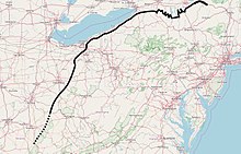
The Portage Escarpment is a major landform in the U.S. states of Ohio, Pennsylvania, and New York which marks the boundary between the Till Plains to the north and west and the Appalachian Plateau to the east and south.
Its proximity to Lake Erie creates a narrow but easily traveled route between upstate New York and the Midwest.
[1] The Portage Escarpment forms the northern and western boundary between the Appalachian Plateau and the Till Plains of the Central Lowland physiographic section of the United States.
[12] In New York state, the Portage Escarpment (also known as the "Finger Lakes sedimentary deposit")[13] consists of sandstone interbedded with shale.
[16] Prior to the Wisconsin glaciation (the last ice age), roughly 24 major rivers flowed north over the escarpment.
When the ice age ended about 10,000 years ago, these gouges filled with water coming down the escarpment and became the 11 Finger Lakes.
The glacial gouging and subsequent erosion by rivers and streams has led to the creation of deep valleys which extend southward as far as the southern tip of the Finger Lakes.
[3] Here, the plain continues to be bounded by the Portage Escarpment, which turns southwest in a series of indefinite hills at Hamburg, Orchard Park, and East Aurora.
The upper terrace of the escarpment is difficult to distinguish from the Appalachian Plateau beyond, because both are eroded so deeply by water.
[28][29] Southwest of the Scioto River, the escarpment forms the western boundary of the Shawnee–Mississippian Plateau region, the most rugged area in Ohio.
[1] That portion of the Erie Plain between Lake Erie and the Portage Escarpment connects the Central Lowland of the Midwest with the Mohawk Valley in the east, and provides the only natural, low-lying route north of the Gulf Coast to the North American interior from the Atlantic seaboard.
[30] Settlement of Ohio largely occurred along the Erie Plain, following the natural route created adjacent to the Portage Escarpment barrier.