Erie Plain
[7] Due to its lacustrine origin, much of the soil of the Erie Plain contains abundant clay, although in some areas it is quiet sandy where ancient beaches formed.
[14] From Erie, Pennsylvania, to Cleveland, the plain broadens to about 4 to 6 miles (6.4 to 9.7 km)[2] and is starkly defined by the Portage Escarpment,[15] which rises in three terraces.
South of Georgian Bay, the Niagara Escarpment lifts the Huron Plain to more than 1,500 feet (460 m) above sea level.
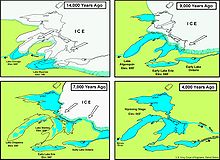
[10] The Erie Plain lacks distinguishing features, except for occasional recessional moraines, and the remnants of proglacial lake beaches and lakeside cliffs.
[14] Cushing, Leverett, and Van Horn identify at least three moraines between Erie, Pennsylvania, and Ohio's Rocky River: The Cleveland, the Euclid, and the Defiance.
[11] West of the Rocky River are three ridges (the North, Middle, and Butternut) roughly paralleling the modern lakeshore, ancient beaches formed by proglacial expansions of Early Lake Erie.
In the far northwest of the state, settlement was inhibited by the poorly drained portion of the Erie Plain known as the Great Black Swamp.
[30] The Erie Plain in extreme northwest Ohio is not as well-drained as that in the rest of the state, as glacial moraines partially block water in the area.
[31] From the beginning of recordkeeping in the early 1800s to 1921, the average rainfall on the plain was about 34 inches (86 cm) a year, with the rainiest months being June and July and the driest October.
[32] Prior to human settlement, the combination of landform and rainfall left the Erie Plain with typical prairie plants.
[33] Marshes and shallow lakes formerly dotted the landscape here, but human-caused drainage since 1800 has largely erased these and left highly fertile plains behind.
However, the large cities which line Lake Erie tend to create urban heat islands which can cause local instabilities.