Portage
Small canoes can be portaged by carrying them inverted over one's shoulders and the center strut may be designed in the style of a yoke to facilitate this.
Some portages involve very little elevation change, such as the very short Mavis Grind in Shetland, which crosses an isthmus.
Where the river bottom was shallow and firm, voyageurs would stand in the canoe and push it upstream with 3-metre (10 ft) poles.
(The most extreme case of tracking was in the Three Gorges in China where all boats had to be pulled upstream against the current of the Yangtze River.)
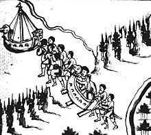
One portage or canoe pack would be carried by a tumpline and one on the back (strangulated hernia was a common cause of death).
To allow regular rests the voyageur would drop his pack at a pose about every 1 kilometre (1⁄2 mi) and go back for the next load.
The 6-to-8.5-kilometre-long (3+1⁄2–5+1⁄2 mi) roadway was a rudimentary form of railway,[2] and operated from around 600 BC until the middle of the 1st century AD.
[2] There is scant literary evidence for two more ship trackways referred to as diolkoi in antiquity, both located in Roman Egypt: The physician Oribasius[7] (c. 320–400 CE) records two passages from his first-century colleague Xenocrates, in which the latter casually refers to a diolkos close to the harbor of Alexandria, which may have been located at the southern tip of the island of Pharos.
[1] Another diolkos is mentioned by Ptolemy (90–168 CE) in his book on geography (IV, 5, 10) as connecting a false mouth of a partly silted up Nile branch with the Mediterranean Sea.
Cosmas describes the dragging of small boats as common in his day for local trade between Thrace and Gothograecia.
It would have been too costly to regularly move large ships across the peninsula, but Cosmas says that Constantine IV did it, presumably during the blockade of Constantinople (670/1–676/7) when the Sea of Marmara and the Dardanelles were controlled by the Umayyads.
The land link between Adige River and Garda Lake in Northern Italy, hardly used by the smallest watercraft, was at least once used by the Venetian Republic for the transport of a military fleet in 1439.
In the 8th, 9th and 10th centuries, Viking merchant-adventurers exploited a network of waterways in Eastern Europe, with portages connecting the four most important rivers of the region: Volga, Western Dvina, Dnieper, and Don.
At the most important portages (such as Gnezdovo) there were trade outposts inhabited by a mixture of Norse merchants and native population.
The passage between the Chicago and Des Plaines Rivers was through a short swamp portage which seasonally flooded and it is thought that a channel gradually developed unintentionally from the dragging of the boat bottoms.