Poverty Point
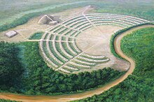
The Poverty Point site contains earthen ridges and mounds, built by indigenous people between 1700 and 1100 BCE during the Late Archaic period in North America.
[4] Archaeologists have proposed a variety of possible functions for the site, including as a settlement, a trading center, and/or a ceremonial religious complex.
The earthworks core of the site measures about 345 acres (140 ha), although archaeological investigations have shown that the total occupation area extended for more than three miles (5 km) along the Bayou Macon.
In addition to filled gullies, archaeologists found that soil was added to raise the level of the ground surface in some areas by as much as 3.3 ft (1 m).
Researchers suggest instead the reported lens represents a fine gray silt common to E horizon soils on the Macon Ridge and often found beneath mounds.
Mound C is composed of several thin layers of distinct soils with small amounts of accumulated debris, or midden, between them, indicating they were added over time.
The Ballcourt designation comes from "two shallow depressions on its flattened top which reminded some archaeologists of playing areas in front of outdoor basketball goals, not because of any suggestion of actual activities at Poverty Point.
Several of the recovered artifacts were of nonlocal chert, such as novaculite, characteristic of the Poverty Point site raw material assemblage.
Artifacts typical of the early date, such as baked loess blocks and Evans projectile points, were recovered near the mound.
[28][29][30] Archaeological excavations determined that prior to the construction of the earthworks, prehistoric workers leveled the land around the site and filled in gullies and other low places to create the flat central plaza and surfaces on which to build the mounds and ridges.
The main building material was loess, a type of silt loam soil which is easy to dig but erodes when exposed to water.
The baskets, depending on the size of the bearer, could hold between 30–50 lb (13.6–22.7 kg) of dirt, suggesting that men, women, and children participated in the construction.
Gibson also suggests that workers lived on-site during construction, possibly setting up temporary homes on top of the very earthworks that they were building.
[34] Changes in temperature, precipitation, and increased flooding, may have caused an ecological imbalance that led to the abandonment of Poverty Point.
[36] Archaeologists such as Sherwood Gagliano and Edwin Jackson support the interpretation that Poverty Point was a site where groups came to meet and trade on an occasional basis.
[37] Gibson believes there is evidence of too much rubbish left by original inhabitants for only occasional habitation, and that it would be implausible to build such a massive earthwork for use only as a trading center.
Archaeologist William Haag, who excavated at the site in the 1970s, interpreted the aisles that divide the ridge sectors as having astronomical significance aligned to the solstices.
[citation needed] The people who lived at Poverty Point were Native Americans, descendants of the immigrants who came to North America across the Bering Strait land bridge approximately 20,000 to 23,000 years ago.
[42] Time, cultural change, and the lack of written records prevent researchers from identifying the people of Poverty Point as ancestors to any specific historic or modern tribe.
[44] Except for unique specialized forms, archaeologists generally conclude the fired earth objects were used in cooking, based on the artifacts recovery context and supported by experimental archaeology.
[45] The inhabitants of Poverty Point produced small amounts of pottery, creating a variety of different types such as fiber-tempered, grog-tempered, and untempered with both the Wheeler and Old Floyd Tchefuncte design styles as decoration.
[47] Most of the Poverty Point tools appear to have been made on-site, as there is evidence of debris from their manufacturing process found across the ridges.
Based on the distant geological sources of different kinds of stone used to make lithic artifacts recovered at Poverty Point, archaeologists conclude that the inhabitants were active in trade with other Native Americans.
For example, a disproportionate number of projectile points were made from raw materials naturally occurring in the Ouachita and Ozark mountains, and in the Ohio and Tennessee river valleys.
Other materials derived from trade included soapstone from the southern Appalachian Mountains of Alabama and Georgia, and galena from Missouri and Iowa.
Archaeologists assumed that the presence of copper artifacts indicated trade with copper-producing tribes in the upper Great Lakes region.
[52] Three excavation seasons in 1952, 1953 and 1955 were undertaken by James A. Ford and Clarence Webb, leading to the publication of Poverty Point, a Late Archaic Site in Louisiana in 1956.
Michael Hargrave and Berle Clay conducted a large area geophysical survey from 2006 to 2012, using magnetic gradiometry and resistivity to investigate the plaza and ridge system.
[6] In 2013, Lieutenant Governor Jay Dardenne, the ex officio head of the Louisiana Department of Culture, Recreation and Tourism, requested $750,000 in emergency state funding to limit erosion at Poverty Point.
[citation needed] In January 2013, the United States Department of the Interior nominated Poverty Point for inclusion on the UNESCO World Heritage List.