Poynings
[4] The village is located on the north side of the South Downs near Devil's Dyke, five miles (8 km) north-west of Brighton.
There is a public house, the Royal Oak, in the village which is a popular stop off point for walkers ascending the scarp slope.
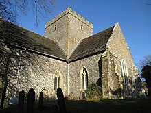
With its big, centralised, empty interior it has been noted that it feels more like a grand old mosque than the usual homely busy-ness of many medieval parish churches.
[13] In the village opposite Holy Trinity Church there is a small sheltered memorial called Cora's Corner, which pays tribute to a former resident of Poynings; two benches in the shelter, Judy's Seat and Merrilee's Seat, are tributes to Cora's two daughters.
It must have once joined to the other woods, but the intervening ground to its east is fertile Lower Greensand, and so was farmed and ploughed centuries ago.
The wood is rich in fungi, often colourful, and has big old hornbeam stools under an ash canopy, over anemones, primroses, bluebells and orchids.
In medieval times formed part of the de Poynings family deer park, and may have been much more open.
The northern section partly retains its hornbeam coppice structure, over plentiful bluebells and is botanically rich.
The wood has a mixture of intact hazel coppice with very tall, clean oak standards at its east end, and heavy pine planting elsewhere.
The most varied and interesting route is The Bostal Road, a bridlepath, which curves through the woods and at its top passes the Iron Age ramparts above the Dyke Valley.
Another path, which was called the Butter Track two centuries ago, takes you steeply up the scarp to the Dyke Pub.
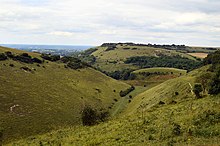
It Is a 300 feet (91 m) deep valley carved by water running off the Downs during the last Ice Age over freeze-thaw cycles.
It is a peaceful place and its steep northern slopes are covered in cowslips in spring and fragrant orchid in early summer.
[13] Adder Bottom (TQ 253 101) has the lynchet lines of an Iron Age field system visible in good evening light.
There is prehistoric bowl barrow (TQ 252 101) called Scabes Castle which marks the corner of the Poynings and Fulking parishand the Brighton boundary.