Slaugham
It is located 7 miles (11 km) to the south of Crawley, on the A23 road to Brighton.
The civil parish covers an area of 2,432 hectares (6,010 acres).
At the 2011 Census the parish included the villages of Handcross and Warninglid and had a population of 2,769.
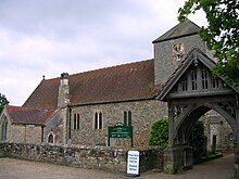
St Mary's Church is a Grade II* listed building dating mostly from the 12th and 13th centuries and is situated opposite Slaugham's village green.
[4][5] Church Covert wood off Staplefied Road is managed by the Woodland Trust.