Central Lancashire
Central Lancashire New Town was the largest of the post-war English new towns, designated in 1970[1] and covering 35,255 acres (143 km2): the County Borough of Preston, parts of Chorley, Fulwood, Leyland, Walton-le-Dale, Chorley Rural District and Preston Rural District.
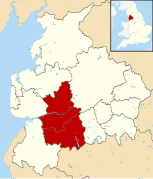
Since 2008, Central Lancashire is an area of joint spatial planning covering the Lancashire districts of the City of Preston, the Borough of South Ribble and the Borough of Chorley, referring to the area covered by the three districts.
[3] A joint Local Development Framework was adopted in 2012.
[citation needed] The Office for National Statistics gives the 2011 population of the Preston Built-up Area, covering Preston, Leyland, Chorley, Bamber Bridge, Fulwood, Hutton, Longton, Adlington, Grimsargh and Euxton, as 313,322.
This Lancashire location article is a stub.