Provincial Route 2 (Buenos Aires)
The entire road is currently managed by State-owned company "Autopistas de Buenos Aires S.A.", also known for its acronym "AUBASA".
[8] Some interesting points are the Chascomús Lake (distant 300 m from the Autovía), the Autódromo Roberto José Mouras (a motor racing circuit named in memory of a famous Argentine racer), the industrial park of La Plata and the Chis-Chis Lake, famous for its fishing activities.
[8] At the south of Salado River, the route passes near to Estancia Villa La Raquel, a huge land with a castle built by the Guerrero family in Castelli Partido during the 19th century.
[11] The road then passes Astor Piazzolla International Airport and after a traffic circle in km 400, the Autovía becomes a boulevard.
Bullock carts ("Carretas" in Spanish) travelled by a road extended from Buenos Aires to the Salado River at the end of the 18th century.
The dirt road from Buenos Aires to Mar del Plata was built by Touring Club Argentino around 1910.
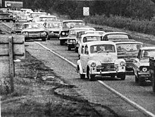
[18] Using this road (which conditions used to get worse when it rained), the vehicles took almost 2 days to reach Mar del Plata from Buenos Aires.
The other important reason to pave the route was to promote tourism, considering that this was Mar del Plata and other cities' main economic activity by then.
[3] In May 1934 the National and Provincial (Buenos Aires) Governments signed an agreement which divided the construction of a paved road into two stages, using the path indicated by Dirección Nacional de Vialidad.
Finally, on October 5, 1938, the entire paved road was opened, after three years of work between Dolores and Mar del Plata.
The stretch from Buenos Aires to Chascomús was modified in order to the road passes by lands nearer to the city of La Plata.
Besides, an iron bridge was built in the Bosques district and an embankment was conceived in order to the railroad tracks passed over the route in Sarandí.
[25] The paved road increased the number of tourists that arrived to Mar del Plata and other cities using their cars.
[26] On 5 October 1941 Route 2 became a National road,[27] from which Route 2 started in Nicolás Avellaneda Bridge over the Riachuelo River (opened a year before), following its path through Sargento Ponce and Debenedetti Avenues in Wilde, Buenos Aires, and then connecting with Presidente Mitre Avenue to the South East direction.
For that reason, the national and provincial governments together planned to build a highway between Buenos Aires and La Plata, which included an access to Route 2 in Rotonda Gutiérrez.
[32] Through Decree #1595 (1979), the National Government transferred the stretch between Acceso Sudeste and the intersection with PR 36 to Buenos Aires Province.
The contract of concession specifies that current dual carriageway could become a highway, as well as a reconstruction of the curves to raise the speed limit to 120 km/h in those sectors.