Quantock Hills
The Quantock Hills west of Bridgwater in Somerset, England, consist of heathland, oak woodlands, ancient parklands and agricultural land.
[2] The hills run from the Vale of Taunton Deane in the south, for about 15 miles (24 km) to the north-west, ending at Kilve and West Quantoxhead on the coast of the Bristol Channel.
This area falls within the Blue Anchor to Lilstock Site of Special Scientific Interest (SSSI) and is considered to be of international geological importance.
Along this coast, the cliffs are layered with compressed strata of oil-bearing shale and blue, yellow and brown Lias embedded with fossils.
[10] Now used as a garage, the kiln is thought to have operated until the 1870s, when the large-scale production of bricks in Bridgwater rendered small brickyards uneconomic.
[11] Cockercombe tuff is a greenish-grey, hard pyroclastic rock formed by the compression of volcanic ash and is found almost exclusively in the south-eastern end of the Quantock Hills.
The mean temperature is approximately 10 °C (50 °F) and shows a seasonal and a diurnal variation, but because of the modifying effect of the sea the range is less than in most other parts of the United Kingdom.
The areas where there is limited drainage are dominated by heather (Calluna vulgaris), with significant populations of cross-leaved heath (Erica tetralix), purple moor-grass (Molinia caerulea), bilberry (Vaccinium myrtillus) and wavy hair-grass (Deschampsia flexuosa).
Drier areas are covered with bell heather (Erica cinerea), western gorse (Ulex gallii) and bristle bent (Agrostis curtisii), while bracken (Pteridium aquilinum) is common on well-drained deeper soils.
Many bird species breed on the Quantocks, including the grasshopper warbler (Locustella naevia), nightjar (Caprimulgus europaeus), raven (Corvus corax) and the European pied flycatcher (Ficedula hypoleuca).
Invertebrates of note include the silver-washed fritillary butterfly (Argynnis paphia), and three nationally rare dead-wood beetles: Thymalus limbatus, Orchesia undulata and Rhinosimus ruficollis.
Iron Age sites in the Quantocks include major hill forts at Dowsborough and Ruborough, as well as several smaller earthwork enclosures, such as Trendle Ring and Plainsfield Camp.
Ruborough near Broomfield is on an easterly spur from the main Quantock ridge, with steep natural slopes to the north and south east.
[14] The Dowsborough fort has an oval shape, with a single rampart and ditch (univallate) following the contours of the hill top, enclosing an area of 7 acres (2.8 ha).
The main entrance is to the east, towards Nether Stowey, with a simpler opening to the north west, aligned with a ridgeway leading down to Holford.
A col to the south connects the hill to the main Stowey ridge, where a linear earthwork known as Dead Woman's Ditch cuts across the spur.
The majority were struck in the reigns of emperors Constantius II and Julian and derive from a range of mints including Arles and Lyons in France, Trier in Germany and Rome.
[16] The area remained under Romano-British Celtic control until 681–685 AD, when Centwine of Wessex pushed west from the River Parrett, conquered the Welsh King Cadwaladr, and occupied the rest of Somerset north to the Bristol Channel.
[21] Alfred established a series of forts and lookout posts linked by a military road, or herepath, so his army could cover Viking movements at sea.
The herepath has a characteristic form that is familiar on the Quantocks: a regulation 66-foot (20 m) wide track between avenues of trees growing from hedge laying embankments.
[25] The Blue Lias rubble walling is the only visible structural remains of the castle, which stand on a conical earthwork with a ditch approximately 820 ft (250 m) in circumference.
[26] The castle was destroyed in the 15th century, which may have been as a penalty for the local Lord Audley's involvement in the Second Cornish Uprising of 1497 led by Perkin Warbeck against the taxes of Henry VII.
When Taunton fell to parliamentary troops and was held by Robert Blake, he attacked Stawell at Bishops Lydeard and imprisoned him.
Inside the church, carved bench-ends dating from 1534[33] depict such pagan subjects as the Green Man and the legend of the men of Crowcombe fighting a two-headed dragon.
The path travels through many types of landscape, including deciduous and coniferous woodland, private parkland, grazed pasture and cropped fields.
[1] Notice of the intention to create the AONB under The Quantock Hills Area of Outstanding Natural Beauty (Designation) Order, 1956 was published in the London Gazette on 7 February 1956.
The JAC represents County, District and Parish councils along with representatives from Natural England, Friends of Quantock, the Forestry Commission, The Country Land and Business Association (CLA), Somerset Local Access Forum, the Quantock Commoners Association, the Federation of Small Businesses, the National Trust, and the National Farmers Union.
Headlining acts have included Sir James Galway, guitarist John Williams and choral groups The Sixteen, The Tallis Scholars and the Gabrieli Consort.
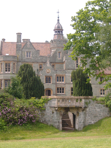
[64] The manor, which is mentioned in the Domesday Book, was at one time used by Cardinal Beaufort as a hunting lodge and thereafter as a family home until the mid-1960s[65] when it became the folk music centre.
The grounds contain many fish ponds, cascades, bridges and fanciful buildings,[67] including the Temple of Harmony, which stands in Mill Wood[68] and has now been fully restored.