South Downs National Park
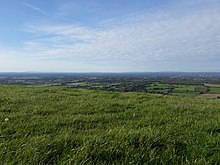
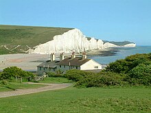
The national park covers the chalk hills of the South Downs (which on the English Channel coast form the white cliffs of the Seven Sisters and Beachy Head) and a substantial part of a separate physiographic region, the western Weald, with its heavily wooded sandstone and clay hills and vales.
Extensive damage to the chalk downland from 1940 onwards through arable farming, and a resulting decline in sheep grazing, militated at an early stage against further work on designation.
As a result of objections and representations received on the proposed Order, a public inquiry was conducted between 10 November 2003 and 23 March 2005,[4] with the aim of recommending to ministers whether a national park should be confirmed and, if so, where its boundaries should be.
The results of the inquiry were expected by the end of 2005, but were delayed pending a legal issue arising from a High Court case challenging part of the Order designating the New Forest National Park.
[5] Following an appeal on the High Court case and new legislation included in the Natural Environment and Rural Communities Act 2006,[6] the South Downs Inquiry report was published on 31 March 2006.
It recommended a 23% reduction in the size of the originally proposed national park, focussing it more narrowly on the chalk downland and excluding from it a large part of the existing East Hampshire and Sussex Downs AONBs.
This proved controversial, leading to calls from the Campaign for the Protection of Rural England and others for the inclusion of the so-called western Weald, a region within the two AONBs possessing a geology, ecology and landscape quite different from the chalk hills of the South Downs, within the park boundary to ensure that it remained protected from development.
The Secretary of State invited objections and representations on new issues relating to the proposed national park in a consultation that ran from 2 July to 13 August 2007.
The occasion was marked by an opening ceremony which took place in the market square of Petersfield, a town in the western Weald just 4 km (2.5 mi) north of the chalk escarpment of the South Downs.
The board consists of seven national members, appointed by the environment secretary by means of an open recruitment process; fourteen local authority nominees drawn from the fifteen local authorities covering the park area (with Adur and Worthing opting to share a place); and six parish council representatives, two for each county.
In its western half, the southern boundary of the park lies up to 10 km (6.2 mi) inland from the south coast; it thus excludes the major coastal towns and cities of Southampton, Portsmouth, Chichester, Bognor Regis and Littlehampton.
Further east, where the park's southern boundary lies much closer to the coast, it has been carefully drawn to exclude the urban areas of Worthing, Brighton and Hove, Newhaven, Seaford and Eastbourne, which had all made substantial encroachments onto the Downs during the 19th and 20th centuries.
[16] However, almost a quarter (23%) of the national park consists of a quite different and strongly contrasting physiographic region, the western Weald, whose densely wooded hills and vales are based on an older Wealden geology of resistant sandstones and softer clays.