Section (United States land surveying)
In 1832 the smallest area of land that could be acquired was reduced to the 40-acre (16 ha) quarter-quarter section, and this size parcel became entrenched in American mythology.
This system was of great practical value on the American frontier, where surveyors often had a shaky grasp of mathematics and were required to work quickly.
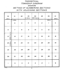
The establishment of standard east-west and north-south lines ("township" and "range lines") meant that deeds could be written without regard to temporary terrain features such as trees, piles of rocks, fences, and the like, and be worded in the style such as "Lying and being in Township 4 North; Range 7 West; and being the northwest quadrant of the southwest quadrant of said section," an exact description in this case of 40 acres, as there are 640 acres (260 ha) in a square mile.
This law provided that lands outside the then-existing states could not be sold, otherwise distributed, or opened for settlement prior to being surveyed.
[5] On May 20, 1862, President Abraham Lincoln signed into law the Homestead Act, by which settlers could "claim" 160 acres (a quarter section) of public land.
After five years, the original filer of the claim was entitled to the property, free and clear, except for a small registration fee.
Sections also differ from the PLSS ideal of one square mile for other reasons, including errors and sloppy work by surveyors, poor instrumentation, and difficult terrain.
Once established, even an imperfect grid remains in force, mainly because the monuments of the original survey, when recovered, hold legal precedent over subsequent resurveys.
[3] Where Spanish land grants in Florida have descriptions that predate PLSS or even the U.S. itself, deviation from typical section numbering and size and shape often takes place.
Often, the amount of land left over in areas immediately surrounding the grants was grossly undersized or awkwardly shaped.
Also, land north of the Watson Line near the Georgia border was not subject to the standard U.S. section, township and range designations, since the State of Georgia had claimed and laid out counties and surveyed its public lands south of that line into what eventually became part of the State of Florida.