Quebec City–Windsor Corridor
For most of its length, the corridor runs through a narrow strip of farmland with the Canadian Shield to the north and the Appalachian Mountains or the Great Lakes to the south.
A drive of only a few minutes north from cities or towns along the eastern two-thirds of the corridor will show an abrupt change from flat farmland and limestone bedrock to the granite hills of the shield.
Because of the moderating influence of the Great Lakes and the frequent influx of warm, moist air from the Gulf of Mexico, the corridor—particularly the western half—has a markedly warmer climate than the rest of Quebec and Ontario.
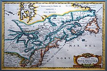
During the French colonization, this area of New France was named Canada and was a single administrative unit under the governor-general (with regional deputy governors in some cities).
The major cross-country route used by voyageurs in the fur trade continued west from Montreal through the Canadian Shield along the Ottawa Valley to Lake Nipissing and Georgian Bay, passing far to the north of what would later become the Ontario part of the corridor.
New France, including the areas that make up the Corridor, were ceded to Great Britain at the end of the conflict; formalized with the signing of the Treaty of Paris.
When the English-speaking United Empire Loyalists arrived in the Province of Quebec as a result of the American Revolution, they settled along the narrow strip north of the St. Lawrence River and lower Great Lakes, where good farm land was available and larger boats could be used for transportation.
By contrast, many of the Ontario towns along the old fur-trading and logging route to the north, through the Ottawa Valley and westward, still have significant French-speaking populations.
The Rideau Canal was constructed to provide a way to bypass the most vulnerable part of the corridor, from Cornwall to Kingston, situated close to the Canada-U.S. border.
Ottawa was eventually chosen as Canada's capital by Queen Victoria precisely because it was further inland and thus less vulnerable to attack, though it is now also considered part of the corridor.
The corridor is held together by a series of major transportation routes – water, road, rail, and air — all running close together and sometimes overlapping each other.


Top left: The Quebec City–Windsor Corridor is the most densely inhabited and heavily industrialized region accounting for nearly 50 percent of the total population [ 1 ]