Queensland borders
By 1838 the coastline of the Australian continent had been well defined by mariners such as James Cook, Matthew Flinders and Phillip Parker King.
As for the interior of Australia, little was known by the European settlers except for the area south of a line from Moreton Bay to Victoria as it is now (the south-east of the continent).
This knowledge had been obtained from the journeys of explorers such as John Oxley, Charles Sturt, Thomas Mitchell, Allan Cunningham and George Evans.
Vetch tried to give each colony equal areas, possess a tract of sea coast with possible harbour sites and be as compact as possible.
Its most recent acquisition (1770) New Holland (now Australia) was chosen and the first penal settlement established at Port Jackson in 1788 by Captain Arthur Phillip.
When William Ewart Gladstone became Secretary of State for the Colonies in 1845, he was confronted with the problem of the large numbers of pardoned convicts roaming around Van Diemen's Land unable to find work.
Also in the same month, the official Letters Patent were issued by Queen Victoria forming a new colony to be called North Australia.
This decision took many months to reach the Governor of New South Wales, Sir Charles Augustus FitzRoy, and then to be transmitted to Barney ordering the abandonment of the North Australia colony and the return to Sydney.
[1] The officials in Port Curtis had endured 4 months of indecision, rain, heat, and mosquitoes before they returned to the civilisation of Sydney where they arrived in May 1847.
[1] In 1823, John Dunmore Lang (1799–1878) a Presbyterian clergyman, politician, immigration organiser, educationist, journalist, patriot and statesman arrived in Sydney to take up his ministry.
[1] Lang soon realised that the poverty he left behind in Britain could be relieved to some extent by emigration to Australia, feeling that a well-off Protestant peasantry would reduce the problems of English industrialism.
[3] Lang's promise of free land in proportion to their passage money was not realised due to colonial bureaucracy and his scheme failed.
[1] During the next few years strong debate ensued, petitions for and against (from both the squatters and merchants in the proposed border area) were sent to the Governor of New South Wales, Sir William Denison, and the Secretary of State for the Colonies in Britain.
Lang kept agitating for his colony, which he proposed to call "Cooksland", after Captain James Cook, where he hoped to settle Protestants as small farmers who would grow crops of cotton and sugar.
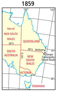
As a result, in 1857 Denison proposed a border starting further north along the coastline at Point Danger (about 28 degrees south latitude).
[1] He wrote to Henry Lebouchere, the Secretary of State for the Colonies and recommended that the boundaries of the new north-eastern colony be:[4]"Starting from Cape Danger and following the range of hills which now separate the district of Clarence River from that of Moreton Bay, it should continue along the ridge forming the boundary of the basins of the Richmond and the Clarence until it reaches the Parallel of 29º of south latitude, along which it should continue westward till it reaches the meridian of 141º East…" On 6 June 1859, Queen Victoria signed the Letters Patent that proclaimed a separate colony from New South Wales was created and to be called Queensland.
It also established the first borders of the state based on Denison's proposal as follows:[5][6]"...Now know you, that We have, in pursuance of the powers vested in Us by the said Bill and Act, and of all other powers and authorities in Us in that behalf vested separated from our Colony of New South Wales, and erected in to a separate Colony, so much of the said colony of New South Wales as lies northward of a line commencing on the sea coast at Point Danger, in latitude about 28º 8’ south, and following the range thence which divides the waters of the Tweed, Richmond, and Clarence Rivers from those of the Logan and Brisbane Rivers, westerly, to the great dividing range between the waters falling to the east coast and those of the River Murray; following the great dividing range southerly to the range dividing the waters of Tenterfield Creek from those of the main head of the Dumaresq River; following that range westerly to the Dumaresq River; and following that river (which is locally known as the Severn) downward to its confluence with the Macintyre River; thence following the Macintyre River, which lower down becomes the Barwan, downward to the 29th parallel of south latitude, and following that parallel westerly to the 141st meridian of east longitude, which is the eastern boundary of South Australia, together with all and every the adjacent Islands, their members and appurtenances, in the Pacific Ocean: And do by these presents separate from our said colony of New South Wales and erect the said territory so described into a separate colony to be called the colony of Queensland..." The western boundary of the colony of Queensland was not clearly described in the Letters Patent of 1859:[5][6]"...downward to the 29th parallel of south latitude and following that parallel westerly to the 141st meridian of east longitude which is the easterly boundary of South Australia..."Legal opinion given at the time stated that the 141st meridian was the western boundary of the colony.
It would therefore be desirable to adopt the 138th meridian as the boundary; as that line would pass through a barren tract of country, and bring Investigator Road [harbour] within the limits of Queensland.
At the direction of the Queensland Surveyor-General, Roberts deviated from the definable position of the watershed in order to increase accuracy of the survey.
[4] The purpose of the survey was to give landholders in the vicinity of the border an indication of the extent of their leases and rent payable in each colony.
WD Campbell reported in The Surveyor in 1895:[4]"In 1865, an arrangement was made between New South Wales and Queensland for the fixing of the position of the intercolonial boundary line, the 29th parallel of latitude, at the intersections of the Rivers Barwon, Mooni, Bokhara, Narran, Biri and Culgoa, to enable the Governments of the respective colonies to adjust the rents of leases of the several pastoral runs affected, some of which were partly in both colonies...
"The official survey of the 29ºS parallel was conducted by John Brewer Cameron (NSW) and George Chale Watson (Qld) between 1879 and 1881.
Many hardships were encountered on the survey, as the line passed through vast stony waterless plains, salt lakes and large sand hills.
After the rains, conditions had improved and the survey recommenced with rapid progress until they reached the ranges north of the Nicholson River.
There, the team experienced all sorts of difficulties including rocky terrain, a fire that destroyed their camp and raids by Aboriginals.
Once they had reached the shores of the Gulf of Carpentaria in September 1886, they erected a large terminal survey post, 50 links above high water mark.
[13] Queensland did not provide a team for the survey but checked the position of the mile post on the border line west of Boulia.
Bedford's second in command, William Davidson, in later years wrote:[14][13]"As white ants were very bad out there, it is quite possible that very few traces remain of our work above ground, but perhaps the bottles of cement we placed at every five miles along our line may prove interesting to scientists of some future generation, should they ever be unearthed.
"In 1988, as a special project for the Australian Bicentenary, the Queensland Division of the Institute of Engineering and Mining Surveyors of Australia retraced Bedford's survey and found his bottles.