Quillehuyte County, Washington
[1] It and Ferguson County[2] are the only two counties of the territory (now the State of Washington) that dissolved, although the Washington Territorial Legislature attempted to dissolve Skamania County in January 1865, but was overruled by the United States Congress.
[3] The county was probably named for the Quileute people, also taken for the Quillayute River, airport, etc.
with varying spellings due to transliteration of their name from the Chimakuan language.
Creation of the county from the western half of Jefferson and a portion of Clallam county (also formed from Jefferson County in 1854) may have been intended to strengthen American land claims and to encourage the Quileute people to vacate to newly established (1855) Quinault reservation.
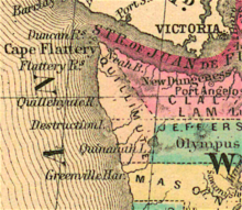
[5] Download coordinates as: Boundaries were set forth by the Territorial Legislature as follows: from the mouth of Wyatch River (now spelled "Waatch") on Makah Bay (48°20′37″N 124°40′31″W / 48.3437°N 124.6752°W / 48.3437; -124.6752 (Mouth of Wyatch River)), southeast through Olympic Mountains "along the summit" to 48°N 124°W / 48°N 124°W / 48; -124 (Olympic Mountains corner), south to Chehalis County boundary (now Grays Harbor County) (47°31′04″N 124°00′00″W / 47.5178°N 124°W / 47.5178; -124 (Chehalis County corner)), west along Chehalis County boundary to Pacific coast at Queets (47°32′00″N 124°21′16″W / 47.5334°N 124.3545°W / 47.5334; -124.3545 (Queets)), north along Pacific coast to origin.