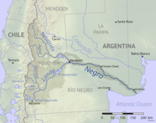
Neuquén River
The river begins in the northwest of the province at an elevation of 2,300 metres (7,500 ft), to be fed by a number of streams through valleys of the lower Andes while advancing diagonally in southeast direction.
The average flow of the river is of 308 cubic metres per second (10,900 cu ft/s) (measured at Paso de Indios), and its drainage basin covers about 50,774 square kilometres (19,604 sq mi).
In the satellite image, the deep reds of the Candeleros Formation, a sequence of sandstones formed roughly 90 to 100 million years ago in a braided river system, dominate the landscape.
Paleontologists have uncovered numerous fossils in the Candeleros rocks, including ancient species of fish, frogs, snakes, turtles, small mammals, and several types of dinosaurs.
[1] The recent discovery of a large deposit of shale gas and oil in the deeper Vaca Muerta formation has made the Neuquén Basin one of the few regions outside of the United States where companies are pursuing horizontal drilling and hydraulic fracturing.