Radar altimeter
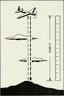
The system transmits radio waves down to the ground and measures the time it takes them to be reflected back up to the aircraft.
Radar altimeters also provide a reliable and accurate method of measuring height above water, when flying long sea-tracks.
This was especially significant at repeater stations, where poorly matched impedances would reflect large amounts of the signal and made long-distance telephony difficult.
[5] Engineers noticed that the reflections appeared to have a "humpy" pattern to them; for any given signal frequency, the problem would only be significant if the devices were located at specific points in the line.
One of his first developments in this field was a 1919 patent (granted 1924)[6] on the idea of sending a signal into railway tracks and measuring the distance to discontinuities.
Studies of radio signals demonstrated they travelled in straight lines, at least over long distances, so the broadcast from Cornwall should have disappeared into space instead of being received in Newfoundland.
In 1902, Oliver Heaviside in the UK and Arthur Kennelly in the USA independently postulated the existence of an ionized layer in the upper atmosphere that was bouncing the signal back to the ground so it could be received.
In 1924, Edward Appleton and Miles Barnett were able to demonstrate the existence of such a layer in a series of experiments carried out in partnership with the BBC.
[7] In 1929, William Littell Everitt, a professor at Ohio State University, began considering the use of Appleton's basic technique as the basis for an altimeter system.
Their experimental system was more in common with the earlier work at Bell, using changes in frequency to measure the distance to the end of wires.
[8][9] The device was taken to Wright Field where it was tested by Albert Francis Hegenberger, a noted expert in aircraft navigation.
Sandretto left Bell in 1932 to become the Superintendent of Communications at United Air Lines (UAL), where he led the development of commercial radio systems.
Around the same time, Bell Labs had been working on new tube designs that were capable of delivering between 5 and 10 Watts at up to 500 MHz, perfect for the role.
The paper explores sources of error and concludes that the worst-case built-in scenario was on the order of 9%,[13] but this might be as high as 10% when flying over rough terrain like the built-up areas of cities.
[13] During early flights of the system, it was noticed that the pattern of the returns as seen on an oscilloscope was distinct for different types of terrain below the aircraft.
[12] It had been known since the late 1800s that metal and water made excellent reflectors of radio signals, and there had been many attempts to build ship, train and iceberg detectors over the years since that time.
Most of these had significant practical limitations due to the use of low-frequency signals that demanded large antennas to provide reasonable performance.
[13][b] In Canada, the National Research Council (NRC) began working on an airborne radar system using the Bell altimeter as its basis.
[14] In France, researchers at IT&T's French division were carrying out similar experiments on radar when the German invasion approached the labs in Paris.
The IT&T director of research deflected suspicion by showing them the altimeter unit on the cover of a magazine and admonishing them for not being up-to-date on the latest navigation techniques.
Then, if the F-111 ever dips below the preset minimum altitude (for example, 15 meters) for any reason, its automatic pilot is commanded to put the F-111 into a 2G fly-up (a steep nose-up climb) to avoid crashing into terrain or water.
The use of radio altimeter equipment is categorised as a safety-of-life service, must be protected for interferences, and is an essential part of navigation.