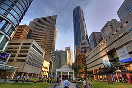
Raffles Place
As part of his plan, he gave instructions in 1822 that a commercial area to be created on the southwest side of the Singapore River.
[3] Under Raffles' supervision, the hill was leveled, and its soil was then used to reclaim the marshy southern bank of the Singapore River, forming the Boat Quay and Circular Road area.
[4] Commercial enterprises were established in the area; two- and four-storey buildings were built around the square, housing mercantile offices, banks and other financial companies.
[3] On the south side of the square were many godowns with jetties where cargo can be loaded and unloaded directly from boats as they were then located at the edge of the sea.
From 1858 to 1864, the land on the south side of Raffles Place from Johnston's Pier to Telok Ayer Market was reclaimed.
The Whiteaway Laidlaw department store building on Battery Road was taken over by Malayan Bank in 1962, and it was later demolished to make way for the Maybank Tower in 1998.
[13] Robinsons moved to Orchard Road after its landmark building was destroyed in one of the worst fires in Singapore's history in 1972, and its neighbour Overseas Union Bank expanded into the site with the construction of a new tower in 1986.
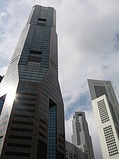
United Overseas Bank tower was completed in 1974 on the old Bonham Building site, later renovated and expanded into UOB Plaza.
[5] The three tallest buildings in Singapore were located on Raffles Place the until the construction of Tanjong Pagar Centre in 2016.
Several key administrative buildings in Singapore, such as the Parliament House, the Supreme Court and City Hall are located north across the river, but are not part of Raffles Place.