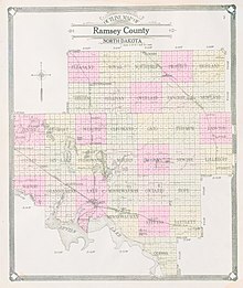
Ramsey County, North Dakota
[4] The southwest boundary of Ramsey County is defined by Devils Lake.
The county terrain consists of rolling hills, dotted with lakes and ponds.
[5] The terrain slopes to the lake, with its highest point at the NE county corner, at 1,631 ft (497 m) ASL.
[13] The population density was 9.8 inhabitants per square mile (3.8/km2) There were 5,843 housing units.
In terms of ancestry, 41.9% were German, 37.7% were Norwegian, 7.0% were Irish, 5.7% were Swedish, 5.2% were English, and 2.9% were American.
In only two national elections since 1944 has the county selected the Democratic Party candidate (as of 2024).