Rarotonga
[3] The island is the summit of an extinct Pliocene or Pleistocene volcano, which rises 5,000 metres (16,000 feet) from the seafloor.
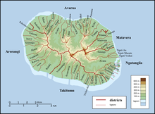
[6] The core of the island consists of densely forested hills cut by deep valleys, the eroded remnants of the original volcanic cone.
The hills are surrounded by a low coastal plain consisting of beaches, a storm ridge, lowland swamps, and alluvial deposits.
[8]: 30 The reef is shallow, with a maximum depth of 1.5 m (4.9 ft),[8]: 31 and has a number of passages, notably at Avarua, Avatiu and Ngatangiia.
Paved and unpaved roads allow access to valleys but the interior of the island remains largely unpopulated due to forbidding terrain and lack of infrastructure.
A tract of 155 ha (380 acres) of land has been set aside in the south-east as the Takitumu Conservation Area to protect native birds and plants, especially the Vulnerable kakerori or Rarotonga monarch.
Oral tradition tells that Rarotonga was settled by various groups, including Ata-i-te-kura, Apopo-te-akatinatina and Apopo-te-ivi-roa in the ninth century, and Tangi'ia Nui from Tahiti and Karika from Samoa in 1250.
In 1865, driven by rumours that France planned to annex the islands, the ariki of Rarotonga unsuccessfully petitioned Governor George Grey of New Zealand for British protection.
[19] In 1945 the industry was revived with a government-led citrus replanting scheme,[20] and in 1961 a canning factory was opened to allow the export of juice.
[24]: 48–49 [26] Flooding in April and May 1967 damaged bridges on the island and caused widespread crop losses, raising risks of a food shortage.
[27] An unnamed tropical cyclone in December of that year left hundreds homeless and caused widespread devastation after demolishing homes and offices in Avarua.
[30] In January 1987 Tropical Cyclone Sally made a thousand people homeless and damaged 80% of the buildings in Avarua.
It passes the Te Rua Manga, the prominent needle-shaped rock visible from the air and some coastal areas.
Popular island activities include snorkeling, scuba diving, bike riding, kite surfing, hiking, deep-sea fishing, boat tours, scenic flights, going to restaurants, dancing, seeing island shows, squash, tennis, zipping around on mopeds, and sleeping on the beach.
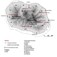
Approximately 29 km (18 mi) long, this road was constructed in 11th century and for most or all of its whole length was paved with large stone slabs.
Along this road are several important marae, including Arai Te Tonga, the most sacred shrine in Rarotonga.