Raritan River
Its watershed drains much of the mountainous areas in the northern and central sections of the state, emptying into the Raritan Bay near Staten Island on the Atlantic Ocean.
Following the end of the last ice age, the Narrows had not yet been formed and the Hudson flowed along the Watchung Mountains to present-day Bound Brook, then followed the course of the Raritan eastward into Lower New York Bay.
[4][5] Following conflict with the arriving Dutch colonists, the native people of the region, especially the Sanhican, were forced to sell their territory near the Raritan Bay and move further inland along the river valley.
[10] The vast majority of traffic along the canal was Pennsylvania anthracite coal with the rest consisting mostly of agricultural and textile goods.
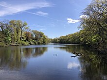
[16] After the confluence of the North and South branches, the Raritan River flows for approximately 16 mi (26 km), before slowing in tidewater at New Brunswick.
Its estuary extends 14 mi (23 km) more, entering the western end of Raritan Bay at South Amboy.
The tidal portions of the river host migratory salt water species such as striped bass, fluke, winter flounder, weakfish and bluefish.
Many songbirds, wading birds, and waterfowl make their homes in and along the length of the river, such as mallards, canadian geese, great blue herons, double-crested cormorants, and common mergansers.
This problem was exacerbated by well-above average rainfall that fell in the weeks before the storm hit, and spurred completion of the Army Corps of Engineers flood control project.