Altstadt (Zurich)
Administratively, District 1 is divided into four parts or quarters by the Zurich statistical office, Rathaus (town hall), Hochschulen (universities), Lindenhof ("lime trees courtyard") and City.
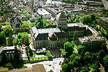
Der Lindenhof ("The lime trees courtyard") quarter corresponds to the mindere Stadt, the smaller but more prestigious half of the medieval town left of the river.
Augustinergasse is a small street leading from St. Peterhofstatt situated at the St. Peter church, passing the former Augustinians monastery below the Lindenhof hill, towards the Kecinstürlin gate at the southern Fröschengraben moat, Bahnhofstrasse as of today.
Zunfthaus zur Meisen at Münsterhof plaza near Fraumünster church houses the porcelain and faience collection of the Swiss National Museum.
The Fraumünster ("women's minster") abbey ruled the town until the 1336 "guild revolution" of Rudolf Brun and which remained highly influential until Zwingli's Reformation.
It is the part of the medieval town on the right side of the Limmat, separated by the Hirschengraben from the Hochschulen quarter to the east, and delimited by the Bellevue and Central squares to the south and north, respectively.
Hochschulen (universities) is wedged between Hirschengraben (the historical course of the eastern moat) and Rämistrasse, corresponding to the area taken up by the eastern fortifications of the 17th century ramparts (destroyed following the 1839 Züriputsch), the hillside now holding the main buildings of both ETH Zurich (built 1861 to 1864 under Gustav Zeuner) and University of Zurich (built 1914 under Karl Moser), at the sites of the Kronen Bollwerk and Schönenberg Bollwerk ramparts, respectively.
Hochschulen in its southern end also includes the Bellevue and Sechseläuten squares as well as the theater and opera house at Stadelhoferplatz and the Stadelhofen train station.
Stops of the Zurich tram system in the Hochschulen quarter are: Central, ETH/Universitätsspital, Kantonsschule, Kunsthaus, Neumarkt, Bellevue, Opernhaus and Stadelhofen.
The Central square at the northern border between Rathaus and Hochschulen quarters is a major junction of the Zurich tram system, served by lines 3, 4, 6, 7, 10 and 15 besides buses 31 and 46.
It comprises the tram stops Bürkliplatz, Paradeplatz, Rennweg, Bahnhofstrasse / Bahnhofplatz / Bahnhofquai, Löwenplatz, Sihlstrasse and Bahnhof Selnau.
From the Bürkliplatz landing gate, Zürichsee-Schifffahrtsgesellschaft boat services leave for Thalwil, Rapperswil, Schmerikon, Erlenbach and down the Limmat to Zürich Landesmuseum.
Selnau (from earlier Sellnau, Seldnau) was historically an estate west of the city, which came to lie between the north-western moat (Schanzengraben) and the Sihl.