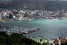
Reclamation of Wellington Harbour
Land plots in the early city were scarce, with little room for public buildings and parks, as well as inadequate dockside areas for shipping.
Reclamation progressively advanced into the harbour throughout the 19th and 20th centuries, providing room for public, commercial and industrial areas for the city.
At the time it commenced operation in 1989, it owned approximately 72 ha (180 acres) of Wellington waterfront property including wharves.
[3] The key elements of his city were a large amount of flat land on the shores of a harbour, traversable by a navigable river.
When surveyors arrived in 1840 on the Cuba led by Captain William Mein Smith, it was determined that the Hutt River was not navigable and, due to its tendency to flood, was not appropriate to support a major city.
[7] Bennet had arrived in 1848 on the Berenicia and purchased a hilly section at Windy, or Clay Point (what is now the corner of Lambton Quay and Willis Street).
At that time, Windy Point was a precipice with a narrow and often impassible path connecting Willis Street to Beach Road (now Lambton Quay).
Bennet commenced, to the amusement of neighbours, with pick-axe, shovel and barrow to move earth from the Point, tossing the spoil onto the path and into the harbour, thus widening the track and performing Wellington's first reclamation.
Among major developments from 1880 to the turn of the century was reclamation north of Pipitea Point for railways land and south of Queens Wharf to Te Aro by the City Council.
When the port company was formed, it owned approximately 72 ha (180 acres) of Wellington waterfront property including wharves.